


Pertuiset,Revard , Gillet de la pierre

nivrach
User
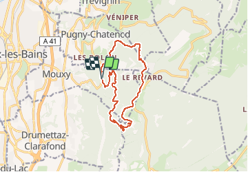

Length
13.4 km

Max alt
1514 m

Uphill gradient
922 m
Km-Effort
26 km

Min alt
693 m

Downhill gradient
917 m
Boucle
Yes
Creation date :
2020-05-19 05:28:32.0
Updated on :
2020-05-19 09:37:55.548
3h14
Difficulty : Unknown

FREE GPS app for hiking
 SityTrail
IGN / Geographical institutes
SityTrail Plus
The world is yours!
About
Trail Walking of 13.4 km to be discovered at Auvergne-Rhône-Alpes, Savoy, Mouxy. This trail is proposed by nivrach.
Positioning
Country:
France
Region :
Auvergne-Rhône-Alpes
Department/Province :
Savoy
Municipality :
Mouxy
Location:
Unknown
Start:(Dec)
Start:(UTM)
730295 ; 5062724 (31T) N.
Comments