


colgardette mai20

gillesmanfredi
User
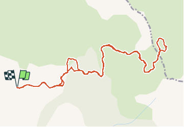

Length
7.4 km

Max alt
2122 m

Uphill gradient
493 m
Km-Effort
14 km

Min alt
1645 m

Downhill gradient
489 m
Boucle
Yes
Creation date :
2020-05-24 08:57:59.463
Updated on :
2020-05-24 13:31:48.629
3h16
Difficulty : Very easy

FREE GPS app for hiking
 SityTrail
IGN / Geographical institutes
SityTrail Plus
The world is yours!
About
Trail Walking of 7.4 km to be discovered at Provence-Alpes-Côte d'Azur, Hautes-Alpes, Chorges. This trail is proposed by gillesmanfredi.
Positioning
Country:
France
Region :
Provence-Alpes-Côte d'Azur
Department/Province :
Hautes-Alpes
Municipality :
Chorges
Location:
Unknown
Start:(Dec)
Start:(UTM)
284438 ; 4940345 (32T) N.
Comments