Chorges, Hautes-Alpes: Best trails, routes and walks

9 comments

Chorges: Discover the best trails: 107 hiking trails and 23 bike and mountain-bike routes. All these trails, routes and outdoor activities are available in our SityTrail applications for smartphones and tablets.


The best trails (135)

Trail Walking Chorges - Chanteloube et lac de Serre Ponçon - Photo
Walking 5.923
Km

Walking

Very easy
(2)
Chorges, Provence-Alpes-Côte d'Azur, Hautes-Alpes, France
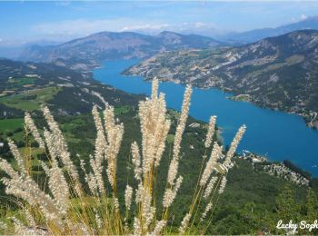
5.9 km | 8.2 km-effort
1h 47min
174 m
172 m
Yes
gildascb

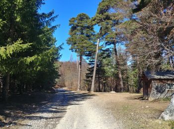
• promenade familiale

Trail Walking Chorges - clôt c l'avais sur fein - Photo
Walking 8.036
Km

Walking

Very easy
(2)
Chorges, Provence-Alpes-Côte d'Azur, Hautes-Alpes, France
8 km | 12.6 km-effort
2h 24min
340 m
342 m
Yes
Didier.kiehl

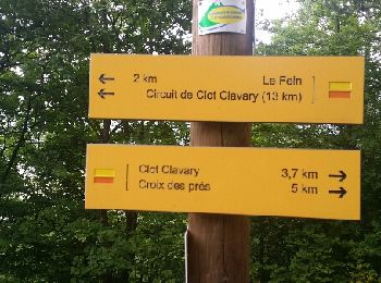
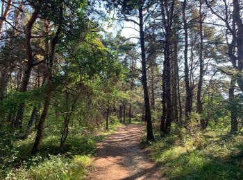
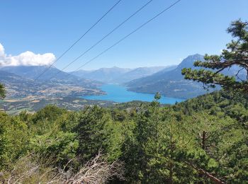
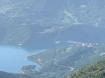
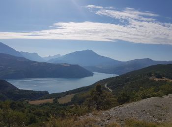
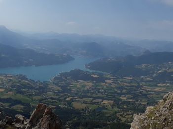
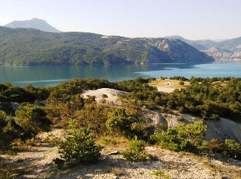
• belle balade sous les bois avec un point de vue sur le lac du serre ponton une bonne mise en jambes pour ce remettre...

Trail Walking Chorges - Les Parias et la Pousterle par le col de Chorges - Photo
Walking 15.381
Km
GUIDE

Walking

Medium
Chorges, Provence-Alpes-Côte d'Azur, Hautes-Alpes, France
15.4 km | 32 km-effort
6h 18min
1266 m
1264 m
Yes
David25400

Trail Walking Chorges - Montagne du Ruban - Photo
Walking 10.987
Km

Walking

Easy
(2)
Chorges, Provence-Alpes-Côte d'Azur, Hautes-Alpes, France
11 km | 17.4 km-effort
3h 39min
480 m
471 m
No
BLANCHET

Trail Walking Chorges - CHORGES camping clé des champs Cantheloube retour par le nord - Photo
Walking 8.674
Km

Walking

Easy
Chorges, Provence-Alpes-Côte d'Azur, Hautes-Alpes, France
8.7 km | 12.1 km-effort
2h 44min
256 m
258 m
Yes
jll7513

Trail Walking Chorges - Bois du Ruban (Clot Clavary - crête du Ruban) - Photo
Walking 12.11
Km

Walking

Easy
Chorges, Provence-Alpes-Côte d'Azur, Hautes-Alpes, France
12.1 km | 19.3 km-effort
3h 52min
542 m
541 m
Yes
gildascb

Trail Walking Chorges - Chorges montagne du bois du Ruban - Photo
Walking 10.733
Km

Walking

Medium
Chorges, Provence-Alpes-Côte d'Azur, Hautes-Alpes, France
10.7 km | 17 km-effort
3h 52min
474 m
473 m
Yes
jll7513

Trail Electric bike Chorges - le tour du lac de Serre Ponçon - Photo
Electric bike 82.531
Km

Electric bike

Medium
Chorges, Provence-Alpes-Côte d'Azur, Hautes-Alpes, France
83 km | 110 km-effort
4h 54min
2084 m
2103 m
No
cailloux54

Trail Walking Chorges - Circuit Col de Chorges/Tête des Parias/La Pousterlle/Col de la Gardette. 27/09/19. - Photo
Walking 10.936
Km

Walking

Very difficult
Chorges, Provence-Alpes-Côte d'Azur, Hautes-Alpes, France
10.9 km | 24 km-effort
8h 32min
980 m
983 m
Yes
Dervalmarc

Trail Walking Chorges - Aiguilles Chabrieres par Col la gardette 06/08/19 - Photo
Walking 11.968
Km
GUIDE

Walking

Very difficult
Chorges, Provence-Alpes-Côte d'Azur, Hautes-Alpes, France
12 km | 23 km-effort
4h 31min
795 m
801 m
Yes
R@ph

Trail Walking Chorges - Circuit de Serre Cocu.  - Photo
Walking 4.519
Km

Walking

Easy
Chorges, Provence-Alpes-Côte d'Azur, Hautes-Alpes, France
4.5 km | 6.8 km-effort
1h 58min
173 m
175 m
Yes
Dervalmarc

Trail Walking Chorges - 20190331_Clot Clavary - Photo
Walking 10.336
Km

Walking

Easy
Chorges, Provence-Alpes-Côte d'Azur, Hautes-Alpes, France
10.3 km | 15.7 km-effort
2h 46min
407 m
397 m
Yes
PapouBertrand

Trail Road bike Chorges - C19 - Le Tour du Lac - Photo
Road bike 85.108
Km
GUIDE+

Road bike

Very difficult
Chorges, Provence-Alpes-Côte d'Azur, Hautes-Alpes, France
85 km | 129 km-effort
6h 39min
3259 m
3259 m
Yes
Camping Les Rives du Lac

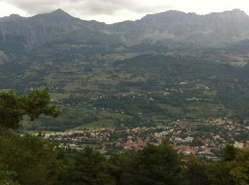
• Beautiful tour, to do in the morning and never Saturday and Sunday for a traffic on the road near Savines and Espinas...

Trail Walking Chorges - Embrunais Le Piolite 2464m - Photo
Walking 7.479
Km

Walking

Medium
Chorges, Provence-Alpes-Côte d'Azur, Hautes-Alpes, France
7.5 km | 16 km-effort
3h 42min
835 m
53 m
No
pascalspr

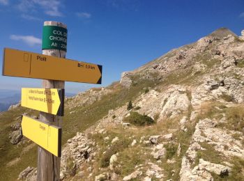
• Parking à la barrière, retour par le même itinéraire.

Trail Walking Chorges - Chorges Le Fein - Photo
Walking 13.915
Km

Walking

Very easy
Chorges, Provence-Alpes-Côte d'Azur, Hautes-Alpes, France
13.9 km | 19.2 km-effort
2h 52min
393 m
393 m
Yes
frederique.marti@laposte.net

Trail Walking Chorges - Le Fein- crète du Ruban- CHORGES - Photo
Walking 14.993
Km

Walking

Medium
Chorges, Provence-Alpes-Côte d'Azur, Hautes-Alpes, France
15 km | 25 km-effort
4h 23min
767 m
620 m
No
BLANCHET

Trail Mountain bike Chorges - 10ème Terr' Des Alpes - Photo
Mountain bike 60.46
Km

Mountain bike

Very difficult
Chorges, Provence-Alpes-Côte d'Azur, Hautes-Alpes, France
60 km | 88 km-effort
6h 30min
2084 m
2085 m
Yes
tracegps

Trail Walking Chorges - Col de la gardette - Photo
Walking 13.458
Km
GUIDE

Walking

Medium
Chorges, Provence-Alpes-Côte d'Azur, Hautes-Alpes, France
13.5 km | 25 km-effort
3h 44min
846 m
858 m
Yes
R@ph

Trail Walking Chorges - 2011-07-07 19h11m19 - Photo
Walking 5.468
Km

Walking

Very easy
(1)
Chorges, Provence-Alpes-Côte d'Azur, Hautes-Alpes, France
5.5 km | 7.7 km-effort
Unknown
168 m
168 m
Yes
Tetraneon

Trail Walking Chorges - Clôt Clavary 3.9.23 - Photo
Walking 7.147
Km

Walking

Easy
Chorges, Provence-Alpes-Côte d'Azur, Hautes-Alpes, France
7.1 km | 11.6 km-effort
2h 0min
331 m
337 m
Yes
fredetpascale

20 trails displayed on 135

FREE GPS app for hiking

Logo SityTrail SityTrail

IGN / Geographical institutes

Download SityTrail from the App Store Download SityTrail from Google Play

Logo SityTrail SityTrail World

The world is yours!

Download SityTrail from the App Store Download SityTrail from Google Play Download SityTrail on Huawei AppGallery

Activities

Close
My subscriptions