Trail Trail Ensuès-la-Redonne - Au Départ de Méjean vers la Vesse - Photo
© OpenStreetMap contributors
Length
Length
21 km
Max alt
Max alt
240 m
Uphill gradient
Uphill gradient
728 m
Km-Effort
Km-Effort  
31 km
Min alt
Min alt
7 m
Downhill gradient
Downhill gradient
723 m
Boucle
Boucle
Yes
Creation date :
2020-05-26 12:30:56.897
Updated on :
2020-05-26 12:34:45.465

(0 Reviews)

Trail
Trail
--
Difficulty : Medium

Scan this QR Code to open this trail in the SityTrail application

FREE GPS app for hiking

Logo SityTrail SityTrail

IGN / Geographical institutes

Download SityTrail from the App Store Download SityTrail from Google Play

Logo SityTrail SityTrail World

The world is yours!

Download SityTrail from the App Store Download SityTrail from Google Play Download SityTrail on Huawei AppGallery

About

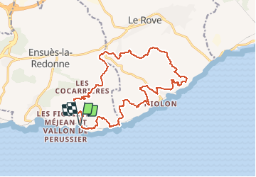
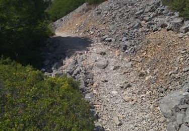
Trail Trail of 21 km to be discovered at Provence-Alpes-Côte d'Azur, Bouches-du-Rhône, Ensuès-la-Redonne. This trail is proposed by countryjack.

Description

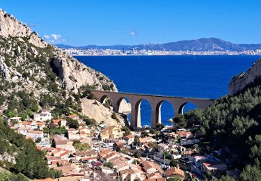
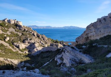
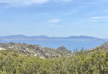
Méjean - Calanque de l'érevine par l'intérieur - Fort de Niolon - Fort de Figuerolles - Puit de l'oeuvre - plateau du médecin - retour

Elevation profile

Positioning

Country:
France
Region :
Provence-Alpes-Côte d'Azur
Department/Province :
Bouches-du-Rhône
Municipality :
Ensuès-la-Redonne
Location:
Unknown
Start:(UTM)
679830 ; 4800055 (31T) N.

Trails nearby

Trail Walking Le Rove - Calanque de la Vesse - Niolon la Vesse - Photo
Walking
tracegps

Walking

Medium
(1)
Le Rove, Provence-Alpes-Côte d'Azur, Bouches-du-Rhône, France
5.7 km | 8.3 km-effort
2h 15min
Yes
Trail Walking Le Rove - Côté bleue  - Photo
Walking
GUIDE
nadinebondoux

Walking

Difficult
Le Rove, Provence-Alpes-Côte d'Azur, Bouches-du-Rhône, France
13.2 km | 18.7 km-effort
4h 39min
Yes
Trail On foot Ensuès-la-Redonne - Grand Sentier de la Côte Bleue - Photo
On foot
GUIDE+

On foot

Very difficult
Ensuès-la-Redonne, Provence-Alpes-Côte d'Azur, Bouches-du-Rhône, France
50 km | 60 km-effort
13h 34min
No
Trail On foot Le Rove - Le fort de Niolon - Photo
On foot
GUIDE+

On foot

Easy
Le Rove, Provence-Alpes-Côte d'Azur, Bouches-du-Rhône, France
4.2 km | 6.6 km-effort
1h 29min
Yes
Trail Walking Le Rove - de Niolon à l'Erévine - Photo
Walking
GUIDE
amiral13

Walking

Easy
(1)
Le Rove, Provence-Alpes-Côte d'Azur, Bouches-du-Rhône, France
7.3 km | 11.1 km-effort
2h 47min
Yes
Trail Walking Le Rove - Cote bleue - Photo
Walking
GUIDE
nadinebondoux

Walking

Difficult
Le Rove, Provence-Alpes-Côte d'Azur, Bouches-du-Rhône, France
18.7 km | 26 km-effort
6h 48min
Yes
Trail Walking Le Rove - le Rove - Photo
Walking
GARROUSTE

Walking

Easy
(1)
Le Rove, Provence-Alpes-Côte d'Azur, Bouches-du-Rhône, France
8.7 km | 11.5 km-effort
2h 32min
Yes
Trail Walking Ensuès-la-Redonne - 13 Méjean ebeverine redonne 02.06.24 - Photo
Walking
GUIDE
randodyssée

Walking

Medium
Ensuès-la-Redonne, Provence-Alpes-Côte d'Azur, Bouches-du-Rhône, France
10.2 km | 14.4 km-effort
3h 28min
No
Trail Walking Ensuès-la-Redonne - La Redonne - Calanques des Anthénors et de Figuières - Photo
Walking
patjobou

Walking

Medium
Ensuès-la-Redonne, Provence-Alpes-Côte d'Azur, Bouches-du-Rhône, France
4.6 km | 6.7 km-effort
1h 46min
Yes


Close
My subscriptions