


2020-05-28_141938

Derrendinger
User

Length
38 km

Max alt
1338 m

Uphill gradient
1180 m
Km-Effort
54 km

Min alt
332 m

Downhill gradient
1180 m
Boucle
Yes
Creation date :
2020-05-30 05:45:36.0
Updated on :
2020-07-25 14:15:12.423
3h26
Difficulty : Very difficult

FREE GPS app for hiking
 SityTrail
IGN / Geographical institutes
SityTrail Plus
The world is yours!
About
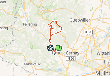
Trail Mountain bike of 38 km to be discovered at Grand Est, Haut-Rhin, Thann. This trail is proposed by Derrendinger.
Positioning
Country:
France
Region :
Grand Est
Department/Province :
Haut-Rhin
Municipality :
Thann
Location:
Unknown
Start:(Dec)
Start:(UTM)
357552 ; 5296241 (32T) N.
Comments