Trail Walking Utelle - Boucle Utelle Madone Chapelle St Antoine - Photo

Boucle Utelle Madone Chapelle St Antoine

 domi06
domi06

User

© OpenStreetMap contributors
Length
Length
11.9 km
Max alt
Max alt
1185 m
Uphill gradient
Uphill gradient
779 m
Km-Effort
Km-Effort  
22 km
Min alt
Min alt
420 m
Downhill gradient
Downhill gradient
785 m
Boucle
Boucle
Yes
Creation date :
2020-05-31 06:51:13.073
Updated on :
2020-06-04 08:47:06.844

(0 Reviews)

Walking
Walking
5h38
Difficulty : Medium

Scan this QR Code to open this trail in the SityTrail application

FREE GPS app for hiking

Logo SityTrail SityTrail

IGN / Geographical institutes

Download SityTrail from the App Store Download SityTrail from Google Play

Logo SityTrail SityTrail World

The world is yours!

Download SityTrail from the App Store Download SityTrail from Google Play Download SityTrail on Huawei AppGallery

About

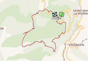
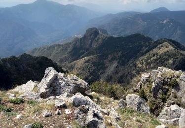
Trail Walking of 11.9 km to be discovered at Provence-Alpes-Côte d'Azur, Maritime Alps, Utelle. This trail is proposed by domi06.

Description

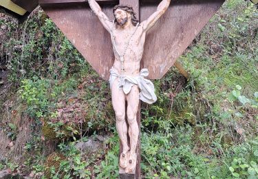
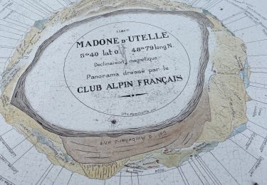
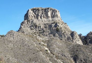
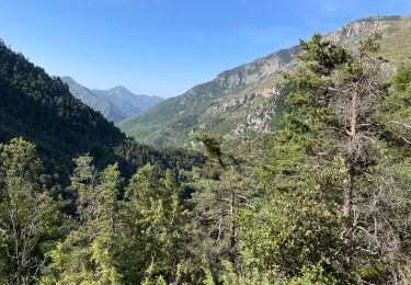
Départ sortie village d'Utelle. Balise 111, 113,114,115 jusqu'au sanctuaire de la Madone d'Utelle. Dirigez-vous vers la table d'orientation située sous une coupole. Revenir en arrière pour prendre un petit sentier descendant Balise117, balisage jaune. Atteindre le col d'Ambellarte, puis direction la chapelle St Antoine. Aller retour de la balise 5. Continuer la descente qui mène au collet de Millehommes, franchir 2 petits canyons. Balise 5a, remonter plein nord un sentier un peu raide. Il faut garder des forces pour la fin!

Elevation profile

Photos

Positioning

Country:
France
Region :
Provence-Alpes-Côte d'Azur
Department/Province :
Maritime Alps
Municipality :
Utelle
Location:
Unknown
Start:(UTM)
359408 ; 4864022 (32T) N.

Trails nearby

Trail On foot Utelle - Gorges de la Vésubie - Photo
On foot
PRO

On foot

Medium
(1)
Utelle, Provence-Alpes-Côte d'Azur, Maritime Alps, France
14.6 km | 27 km-effort
6h 11min
Yes
Trail On foot Utelle - Madone d'Utelle - Photo
On foot
PRO

On foot

Easy
Utelle, Provence-Alpes-Côte d'Azur, Maritime Alps, France
9.9 km | 19.4 km-effort
4h 24min
Yes
Trail Walking Utelle - Cros d Utelle chapelle St Antoine - Photo
Walking
56jj

Walking

Difficult
Utelle, Provence-Alpes-Côte d'Azur, Maritime Alps, France
7.5 km | 13.7 km-effort
4h 6min
Yes
Trail Walking Utelle - Le Chaudan Madone Utelle réel - Photo
Walking
jouans

Walking

Very difficult
Utelle, Provence-Alpes-Côte d'Azur, Maritime Alps, France
19.6 km | 37 km-effort
5h 55min
Yes
Trail Walking Utelle - Utelle, Brec d'Utelle - Photo
Walking
GrouGary

Walking

Very difficult
(1)
Utelle, Provence-Alpes-Côte d'Azur, Maritime Alps, France
11.2 km | 22 km-effort
4h 59min
Yes
Trail Walking Lantosque - Granges de la Brasque  - Photo
Walking
ETMU5496

Walking

Difficult
Lantosque, Provence-Alpes-Côte d'Azur, Maritime Alps, France
22 km | 37 km-effort
5h 28min
Yes
Trail Walking Utelle - Le Brec d'Utelle 1604m 19-04-22 - Photo
Walking
fredetpascale

Walking

Medium
Utelle, Provence-Alpes-Côte d'Azur, Maritime Alps, France
11.2 km | 22 km-effort
4h 15min
Yes
Trail On foot Utelle - Brec d'Utelle - Photo
On foot
PRO

On foot

Medium
Utelle, Provence-Alpes-Côte d'Azur, Maritime Alps, France
11.2 km | 22 km-effort
5h 2min
Yes
Trail On foot Duranus - Mine de l'Eguisse - Photo
On foot
PRO

On foot

Easy
Duranus, Provence-Alpes-Côte d'Azur, Maritime Alps, France
6.8 km | 14.5 km-effort
3h 17min
Yes


Close
My subscriptions