


5071881639112673

duchaine.nicolas
User
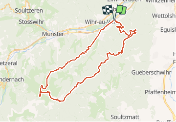

Length
41 km

Max alt
1166 m

Uphill gradient
1355 m
Km-Effort
59 km

Min alt
290 m

Downhill gradient
1354 m
Boucle
Yes
Creation date :
2020-05-31 16:46:03.915
Updated on :
2020-06-08 06:24:27.66
3h47
Difficulty : Medium
--
Difficulty : Medium

FREE GPS app for hiking
 SityTrail
IGN / Geographical institutes
SityTrail Plus
The world is yours!
About
Trail Mountain bike of 41 km to be discovered at Grand Est, Haut-Rhin, Wihr-au-Val. This trail is proposed by duchaine.nicolas.
Description
Wirh Au Val - Stauffen - Firstplan - Boelensgrab - Col du Petit Ballon - Kahlenwasen - Ht Wasserbourg - Soultzbach
Positioning
Country:
France
Region :
Grand Est
Department/Province :
Haut-Rhin
Municipality :
Wihr-au-Val
Location:
Unknown
Start:(Dec)
Start:(UTM)
367654 ; 5323778 (32U) N.
Comments