


SENTHEIM-GUEWENHEIM-SENTHEIM

patrickbeyrath
User
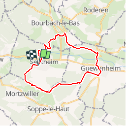

Length
13.4 km

Max alt
437 m

Uphill gradient
268 m
Km-Effort
16.9 km

Min alt
328 m

Downhill gradient
268 m
Boucle
Yes
Creation date :
2018-10-13 05:53:12.427
Updated on :
2018-10-13 05:53:12.445
3h39
Difficulty : Easy

FREE GPS app for hiking
 SityTrail
IGN / Geographical institutes
SityTrail Plus
The world is yours!
About
Trail Walking of 13.4 km to be discovered at Grand Est, Haut-Rhin, Sentheim. This trail is proposed by patrickbeyrath.
Positioning
Country:
France
Region :
Grand Est
Department/Province :
Haut-Rhin
Municipality :
Sentheim
Location:
Unknown
Start:(Dec)
Start:(UTM)
353849 ; 5290712 (32T) N.
Comments