


GR 653 - C

marmotte65
User GUIDE
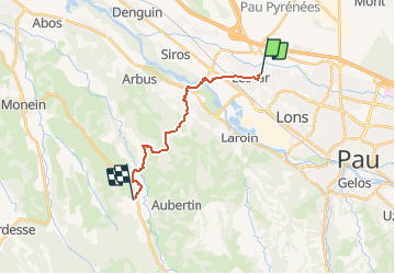

Length
14.6 km

Max alt
296 m

Uphill gradient
237 m
Km-Effort
17.8 km

Min alt
142 m

Downhill gradient
257 m
Boucle
No
Creation date :
2020-06-01 13:47:48.331
Updated on :
2021-02-26 03:38:06.917
--
Difficulty : Medium

FREE GPS app for hiking
 SityTrail
IGN / Geographical institutes
SityTrail Plus
The world is yours!
About
Trail On foot of 14.6 km to be discovered at New Aquitaine, Pyrénées-Atlantiques, Lescar. This trail is proposed by marmotte65.
Positioning
Country:
France
Region :
New Aquitaine
Department/Province :
Pyrénées-Atlantiques
Municipality :
Lescar
Location:
Unknown
Start:(Dec)
Start:(UTM)
708399 ; 4801195 (30T) N.
Comments