


MOLLEON ORCIERES

clintest
User
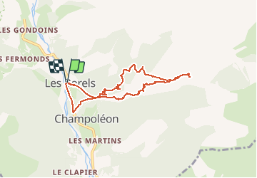

Length
8.3 km

Max alt
1689 m

Uphill gradient
486 m
Km-Effort
14.8 km

Min alt
1264 m

Downhill gradient
486 m
Boucle
Yes
Creation date :
2020-06-02 18:34:20.649
Updated on :
2020-06-02 18:35:20.146
--
Difficulty : Medium

FREE GPS app for hiking
 SityTrail
IGN / Geographical institutes
SityTrail Plus
The world is yours!
About
Trail On foot of 8.3 km to be discovered at Provence-Alpes-Côte d'Azur, Hautes-Alpes, Champoléon. This trail is proposed by clintest.
Description
VILLAGE ANADONNE DEPART DES BORELS
Positioning
Country:
France
Region :
Provence-Alpes-Côte d'Azur
Department/Province :
Hautes-Alpes
Municipality :
Champoléon
Location:
Unknown
Start:(Dec)
Start:(UTM)
282939 ; 4955545 (32T) N.
Comments