


2020 06 Expert Osenbuhr

staubalex
User
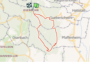

Length
14.4 km

Max alt
597 m

Uphill gradient
389 m
Km-Effort
19.6 km

Min alt
379 m

Downhill gradient
391 m
Boucle
Yes
Creation date :
2020-06-04 18:19:54.585
Updated on :
2020-06-04 18:22:05.012
2h30
Difficulty : Difficult

FREE GPS app for hiking
 SityTrail
IGN / Geographical institutes
SityTrail Plus
The world is yours!
About
Trail Other activity of 14.4 km to be discovered at Grand Est, Haut-Rhin, Pfaffenheim. This trail is proposed by staubalex.
Positioning
Country:
France
Region :
Grand Est
Department/Province :
Haut-Rhin
Municipality :
Pfaffenheim
Location:
Unknown
Start:(Dec)
Start:(UTM)
368522 ; 5318943 (32U) N.
Comments