


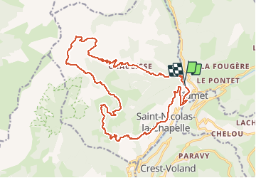
flumet

veroarvinberod
User

Length
22 km

Max alt
1759 m

Uphill gradient
1139 m
Km-Effort
38 km

Min alt
855 m

Downhill gradient
1149 m
Boucle
Yes
Creation date :
2020-06-06 10:15:49.516
Updated on :
2020-06-06 15:30:24.899
5h13
Difficulty : Very easy

FREE GPS app for hiking
 SityTrail
IGN / Geographical institutes
SityTrail Plus
The world is yours!
About
Trail Mountain bike of 22 km to be discovered at Auvergne-Rhône-Alpes, Savoy, Flumet. This trail is proposed by veroarvinberod.
Positioning
Country:
France
Region :
Auvergne-Rhône-Alpes
Department/Province :
Savoy
Municipality :
Flumet
Location:
Unknown
Start:(Dec)
Start:(UTM)
306602 ; 5077216 (32T) N.
Comments