Trail Walking Le Reposoir - Le petit bargy - Photo
© OpenStreetMap contributors
Length
Length
13.5 km
Max alt
Max alt
2092 m
Uphill gradient
Uphill gradient
1073 m
Km-Effort
Km-Effort  
28 km
Min alt
Min alt
1053 m
Downhill gradient
Downhill gradient
1077 m
Boucle
Boucle
Yes
Creation date :
2020-06-08 04:39:04.065
Updated on :
2020-06-08 16:09:01.809

(0 Reviews)

Walking
Walking
4h48
Difficulty : Medium

Scan this QR Code to open this trail in the SityTrail application

FREE GPS app for hiking

Logo SityTrail SityTrail

IGN / Geographical institutes

Download SityTrail from the App Store Download SityTrail from Google Play

Logo SityTrail SityTrail World

The world is yours!

Download SityTrail from the App Store Download SityTrail from Google Play Download SityTrail on Huawei AppGallery

About

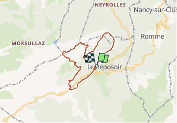
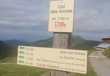
Trail Walking of 13.5 km to be discovered at Auvergne-Rhône-Alpes, Upper Savoy, Le Reposoir. This trail is proposed by guillaume11.

Description

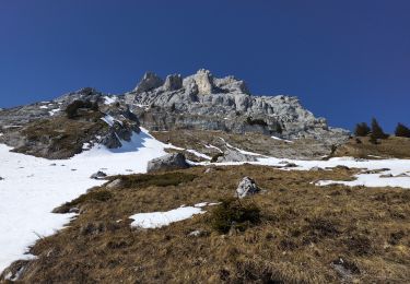
Randonnée sans grosse difficulté technique (quelques passages nécessitant de faire attention),
Terrain glissant en cas de pluie.
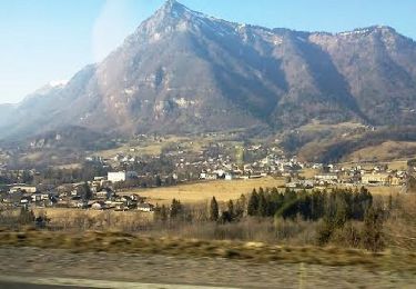
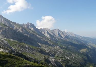
Belle vue sur la vallée et la chaine des Aravis

Elevation profile

Positioning

Country:
France
Region :
Auvergne-Rhône-Alpes
Department/Province :
Upper Savoy
Municipality :
Le Reposoir
Location:
Unknown
Start:(UTM)
309085 ; 5098608 (32T) N.

Trails nearby

Trail Walking Le Reposoir - Le Petit Bargy 2098 m, depuis Malatrait - Photo
Walking
tracegps

Walking

Medium
(1)
Le Reposoir, Auvergne-Rhône-Alpes, Upper Savoy, France
8.1 km | 18.8 km-effort
5h 0min
Yes
Trail Cycle Scionzier - Vallée de l'Arve et du Giffre - Cluses - Photo
Cycle
tracegps

Cycle

Difficult
(1)
Scionzier, Auvergne-Rhône-Alpes, Upper Savoy, France
72 km | 86 km-effort
3h 0min
Yes
Trail On foot Le Grand-Bornand - Move - Photo
On foot
Sebastienburette

On foot

Easy
(1)
Le Grand-Bornand, Auvergne-Rhône-Alpes, Upper Savoy, France
6.5 km | 11.5 km-effort
Unknown
Yes
Trail Walking Le Reposoir - lac peyre - Photo
Walking
Jeroen82

Walking

Medium
(2)
Le Reposoir, Auvergne-Rhône-Alpes, Upper Savoy, France
5.1 km | 10.9 km-effort
2h 26min
Yes
Trail Walking Le Reposoir - Col de la Colombière - Pointe du Midi - Photo
Walking
sofracoan

Walking

Medium
(1)
Le Reposoir, Auvergne-Rhône-Alpes, Upper Savoy, France
11 km | 24 km-effort
3h 59min
Yes
Trail Walking Mont-Saxonnex - lac benit  - Photo
Walking
colomb24

Walking

Easy
Mont-Saxonnex, Auvergne-Rhône-Alpes, Upper Savoy, France
10.8 km | 18.9 km-effort
4h 43min
Yes
Trail Walking Le Grand-Bornand - Le Grand-Bornand ... le Tour du Bois de la Duche. - Photo
Walking
GerardBouche

Walking

Medium
Le Grand-Bornand, Auvergne-Rhône-Alpes, Upper Savoy, France
7.2 km | 12.5 km-effort
2h 23min
Yes
Trail Walking Le Reposoir - Tête d'Auferrand - Photo
Walking
Evelyne Bouchereau

Walking

Difficult
(1)
Le Reposoir, Auvergne-Rhône-Alpes, Upper Savoy, France
7.4 km | 13.2 km-effort
3h 40min
Yes
Trail Touring skiing Le Grand-Bornand - Col de Balafrasse et tout de la pointe Est du midi  - Photo
Touring skiing
nadd73

Touring skiing

Difficult
Le Grand-Bornand, Auvergne-Rhône-Alpes, Upper Savoy, France
14.6 km | 31 km-effort
6h 12min
Yes


Close
My subscriptions