


2020 06 Hirtzenstein Hartmanswillerkopf

staubalex
User
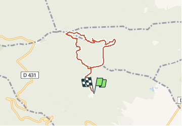

Length
6.4 km

Max alt
952 m

Uphill gradient
457 m
Km-Effort
12.5 km

Min alt
542 m

Downhill gradient
456 m
Boucle
Yes
Creation date :
2020-06-08 11:56:20.624
Updated on :
2020-06-08 13:08:10.086
--
Difficulty : Very easy

FREE GPS app for hiking
 SityTrail
IGN / Geographical institutes
SityTrail Plus
The world is yours!
About
Trail On foot of 6.4 km to be discovered at Grand Est, Haut-Rhin, Wattwiller. This trail is proposed by staubalex.
Positioning
Country:
France
Region :
Grand Est
Department/Province :
Haut-Rhin
Municipality :
Wattwiller
Location:
Unknown
Start:(Dec)
Start:(UTM)
363034 ; 5300890 (32T) N.
Comments