


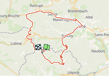
Hingrie climont, Fouchy
© OpenStreetMap contributors


4h35
Difficulty : Very easy


Length
44 km
Max alt
803 m
Uphill gradient
1167 m
Km-Effort
60 km
Min alt
263 m
Downhill gradient
1168 m
Boucle
Yes
Creation date :
2020-06-12 10:48:46.457
Updated on :
2020-06-12 15:25:03.708
4h35
Difficulty : Very easy
FREE GPS app for hiking
 SityTrail
IGN / Geographical institutes
SityTrail Plus
The world is yours!
About
Trail Mountain bike of 44 km to be discovered at Grand Est, Haut-Rhin, Rombach-le-Franc. This trail is proposed by Véronique Baradel Alias Ficelle.
Positioning
Country:
France
Region :
Grand Est
Department/Province :
Haut-Rhin
Municipality :
Rombach-le-Franc
Location:
Unknown
Start:(Dec)
Start:(UTM)
367505 ; 5351259 (32U) N.
Comments