Trail Walking Valdeblore - Baus Frema, Tête du Brec et Mont Petoumier départ Colmiane - Photo

Baus Frema, Tête du Brec et Mont Petoumier départ Colmiane

 GrouGary
GrouGary

User

© OpenStreetMap contributors
Length
Length
12.5 km
Max alt
Max alt
2587 m
Uphill gradient
Uphill gradient
1010 m
Km-Effort
Km-Effort  
26 km
Min alt
Min alt
1578 m
Downhill gradient
Downhill gradient
1010 m
Boucle
Boucle
Yes
Creation date :
2020-06-18 07:29:54.914
Updated on :
2020-06-19 05:54:39.89

(0 Reviews)

Walking
Walking
6h30
Difficulty : Medium

Scan this QR Code to open this trail in the SityTrail application

FREE GPS app for hiking

Logo SityTrail SityTrail

IGN / Geographical institutes

Download SityTrail from the App Store Download SityTrail from Google Play

Logo SityTrail SityTrail World

The world is yours!

Download SityTrail from the App Store Download SityTrail from Google Play Download SityTrail on Huawei AppGallery

About

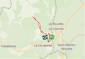
Trail Walking of 12.5 km to be discovered at Provence-Alpes-Côte d'Azur, Maritime Alps, Valdeblore. This trail is proposed by GrouGary.

Description

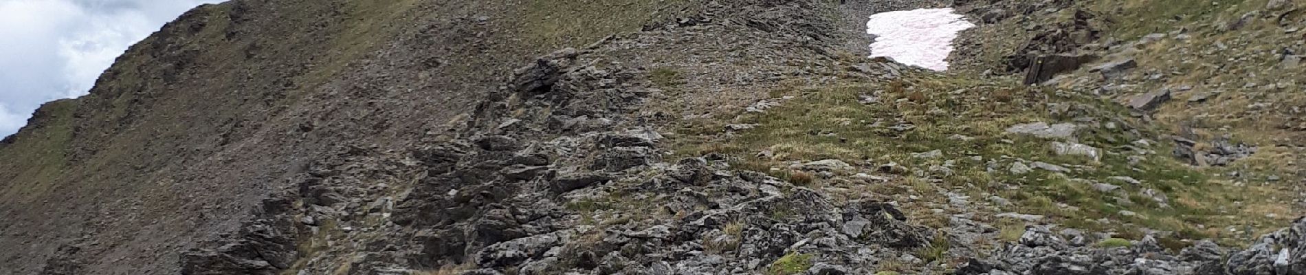
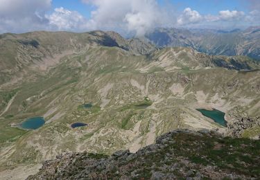
Un petit air de Mongolie du Baus de la frema au Pétoumier : grandes pelouses herbeuses et nombreux chevaux.  Mont Pépoiri à peine distinct dans le rideau brumeux qui s'étire.
Attention aux chevaux : Ne pas traverser leur "territoire" et le contourner car ils foncent au galop sur tout intrus.

Elevation profile

Photos

Positioning

Country:
France
Region :
Provence-Alpes-Côte d'Azur
Department/Province :
Maritime Alps
Municipality :
Valdeblore
Location:
Unknown
Start:(UTM)
358259 ; 4881693 (32T) N.

Trails nearby

Trail Walking Valdeblore - pepoiri  - Photo
Walking
REYPatrick

Walking

Very easy
(1)
Valdeblore, Provence-Alpes-Côte d'Azur, Maritime Alps, France
7.8 km | 16.3 km-effort
5h 31min
Yes
Trail Walking Venanson - La Malouna - Photo
Walking
Benteux

Walking

Medium
(1)
Venanson, Provence-Alpes-Côte d'Azur, Maritime Alps, France
10.7 km | 17.9 km-effort
5h 20min
Yes
Trail On foot Valdeblore - Le Caïre Gros - Photo
On foot
GUIDE+

On foot

Medium
Valdeblore, Provence-Alpes-Côte d'Azur, Maritime Alps, France
9.8 km | 20 km-effort
4h 38min
Yes
Trail On foot Saint-Martin-Vésubie - Col de Cerise - Photo
On foot
GUIDE+

On foot

Medium
Saint-Martin-Vésubie, Provence-Alpes-Côte d'Azur, Maritime Alps, France
9.7 km | 23 km-effort
5h 18min
Yes
Trail On foot Venanson - Circuit du Conquet - Photo
On foot
GUIDE+

On foot

Medium
Venanson, Provence-Alpes-Côte d'Azur, Maritime Alps, France
10.2 km | 21 km-effort
4h 45min
Yes
Trail Touring skiing Valdeblore - Pèpoiri et Petoumier - Photo
Touring skiing
GUIDE
nadd73

Touring skiing

Medium
Valdeblore, Provence-Alpes-Côte d'Azur, Maritime Alps, France
12.8 km | 31 km-effort
6h 44min
Yes
Trail Touring skiing Saint-Martin-Vésubie - Col de cerise et lac du Mercantour - Photo
Touring skiing
GUIDE
nadd73

Touring skiing

Medium
Saint-Martin-Vésubie, Provence-Alpes-Côte d'Azur, Maritime Alps, France
11.9 km | 29 km-effort
7h 39min
Yes
Trail Touring skiing Valdeblore - Mont Giraud - Photo
Touring skiing
GUIDE
nadd73

Touring skiing

Difficult
Valdeblore, Provence-Alpes-Côte d'Azur, Maritime Alps, France
15.7 km | 32 km-effort
7h 41min
Yes
Trail Touring skiing Saint-Martin-Vésubie - Cime de Juisse - Photo
Touring skiing
GUIDE
nadd73

Touring skiing

Medium
Saint-Martin-Vésubie, Provence-Alpes-Côte d'Azur, Maritime Alps, France
14.1 km | 29 km-effort
6h 52min
Yes


Close
My subscriptions