Trail Other activity Schwarzenburg - Schwarzenburg à Mittelhäusern - Photo
 necira
necira

User

© OpenStreetMap contributors
Length
Length
10.6 km
Max alt
Max alt
858 m
Uphill gradient
Uphill gradient
352 m
Km-Effort
Km-Effort  
15.7 km
Min alt
Min alt
574 m
Downhill gradient
Downhill gradient
469 m
Boucle
Boucle
No
Creation date :
2014-12-11 00:00:00.0
Updated on :
2014-12-11 00:00:00.0

(0 Reviews)

Other activity
Other activity
--
Difficulty : Unknown

Scan this QR Code to open this trail in the SityTrail application

FREE GPS app for hiking

Logo SityTrail SityTrail

IGN / Geographical institutes

Download SityTrail from the App Store Download SityTrail from Google Play

Logo SityTrail SityTrail World

The world is yours!

Download SityTrail from the App Store Download SityTrail from Google Play Download SityTrail on Huawei AppGallery

About

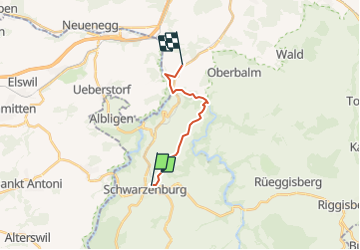
Trail Other activity of 10.6 km to be discovered at Bern, Bern-Mittelland administrative district, Schwarzenburg. This trail is proposed by necira.

Description

Balade qui nous amène le long de la Schwarzwasser jusqu''à son embranchement à la Singine. Il est à noté qu''un passage est très technique pour rejoindre la rivière à l''altitude 601 !!
Très glissant après la pluie !
(595''787/189''717 - 595''837/189''678)
Le reste est pure merveille.
Cette balade a été proposée par 24H edition du jeudi cahier week-end.
Le retour se fait en train, avec une correspondance toutes les 30 minutes !
Une série de photos sur mon site internet www.necira.ch (galerie juin 08)

Elevation profile

Positioning

Country:
Switzerland
Region :
Bern
Department/Province :
Bern-Mittelland administrative district
Municipality :
Schwarzenburg
Location:
Unknown
Start:(UTM)
373823 ; 5186478 (32T) N.

Trails nearby

Trail On foot Tafers - Ober Maggenberg - Melisried - Photo
On foot
PRO

On foot

Easy
Tafers, Fribourg, Sensebezirk, Switzerland
4 km | 5.2 km-effort
1h 10min
No
Trail On foot Rüschegg - Wislisau - Feli - Photo
On foot
PRO

On foot

Easy
Rüschegg, Bern, Bern-Mittelland administrative district, Switzerland
3.5 km | 6.1 km-effort
1h 23min
No
Trail Walking Schwarzenburg - st_Jakobsweg_test - Photo
Walking
GUIDE+

Walking

Very easy
Schwarzenburg, Bern, Bern-Mittelland administrative district, Switzerland
12.8 km | 16.2 km-effort
3h 40min
No
Trail Walking Schwarzenburg - wa37 - Photo
Walking
GUIDE+

Walking

Very easy
Schwarzenburg, Bern, Bern-Mittelland administrative district, Switzerland
11.7 km | 18.3 km-effort
5h 22min
Yes
Trail Other activity Schwarzenburg - Schwarzwasserbrücke - Belp (2) - Photo
Other activity
bffcuc

Other activity

Very easy
Schwarzenburg, Bern, Bern-Mittelland administrative district, Switzerland
16.2 km | 25 km-effort
Unknown
No
Trail Other activity Schwarzenburg - Schwarzwasserbrücke - Belp - Photo
Other activity
bffcuc

Other activity

Very easy
Schwarzenburg, Bern, Bern-Mittelland administrative district, Switzerland
18.3 km | 27 km-effort
Unknown
No
Trail Other activity Schwarzenburg - Schwarzenburg - Belp - Photo
Other activity
bffcuc

Other activity

Very easy
Schwarzenburg, Bern, Bern-Mittelland administrative district, Switzerland
19.6 km | 28 km-effort
5h 59min
No
Trail Other activity Schwarzenburg - Schwarzenburg - Freiburg - Photo
Other activity
hallauer

Other activity

Very easy
Schwarzenburg, Bern, Bern-Mittelland administrative district, Switzerland
12.4 km | 16 km-effort
3h 36min
No


Close
My subscriptions