


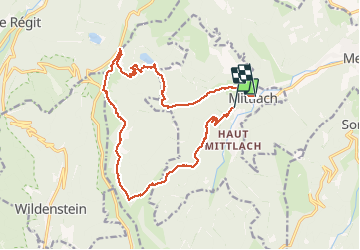
Mittlach 2

nicolas dupré
User

Length
17.1 km

Max alt
1304 m

Uphill gradient
820 m
Km-Effort
28 km

Min alt
530 m

Downhill gradient
914 m
Boucle
No
Creation date :
2020-06-22 08:12:48.0
Updated on :
2020-06-22 13:38:56.95
5h08
Difficulty : Unknown

FREE GPS app for hiking
 SityTrail
IGN / Geographical institutes
SityTrail Plus
The world is yours!
About
Trail Walking of 17.1 km to be discovered at Grand Est, Haut-Rhin, Mittlach. This trail is proposed by nicolas dupré.
Description
Mittlach 2
Positioning
Country:
France
Region :
Grand Est
Department/Province :
Haut-Rhin
Municipality :
Mittlach
Location:
Unknown
Start:(Dec)
Start:(UTM)
352666 ; 5318360 (32U) N.
Comments