


vanoise_polset_fond vallée

m261212
User
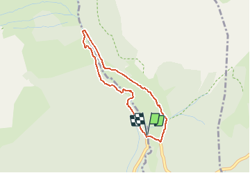

Length
3.2 km

Max alt
1925 m

Uphill gradient
142 m
Km-Effort
5.1 km

Min alt
1774 m

Downhill gradient
147 m
Boucle
Yes
Creation date :
2020-06-22 15:10:58.36
Updated on :
2020-06-26 14:23:27.989
40m
Difficulty : Easy

FREE GPS app for hiking
 SityTrail
IGN / Geographical institutes
SityTrail Plus
The world is yours!
About
Trail Walking of 3.2 km to be discovered at Auvergne-Rhône-Alpes, Savoy, Saint-André. This trail is proposed by m261212.
Positioning
Country:
France
Region :
Auvergne-Rhône-Alpes
Department/Province :
Savoy
Municipality :
Saint-André
Location:
Unknown
Start:(Dec)
Start:(UTM)
315630 ; 5010634 (32T) N.
Comments