


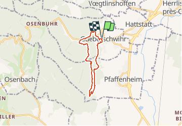
2020 06 Sentier mystique Schauenberg

staubalex
User

Length
9.9 km

Max alt
503 m

Uphill gradient
381 m
Km-Effort
15 km

Min alt
267 m

Downhill gradient
381 m
Boucle
Yes
Creation date :
2020-06-23 16:44:03.695
Updated on :
2020-06-23 16:45:49.68
3h07
Difficulty : Difficult

FREE GPS app for hiking
 SityTrail
IGN / Geographical institutes
SityTrail Plus
The world is yours!
About
Trail Walking of 9.9 km to be discovered at Grand Est, Haut-Rhin, Gueberschwihr. This trail is proposed by staubalex.
Positioning
Country:
France
Region :
Grand Est
Department/Province :
Haut-Rhin
Municipality :
Gueberschwihr
Location:
Unknown
Start:(Dec)
Start:(UTM)
371348 ; 5318265 (32U) N.
Comments