


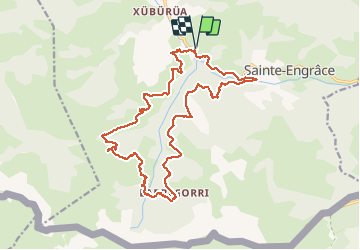
Tour du canyon Kakuetta

mthomas30
User

Length
22 km

Max alt
1332 m

Uphill gradient
1207 m
Km-Effort
38 km

Min alt
463 m

Downhill gradient
1204 m
Boucle
Yes
Creation date :
2020-06-23 08:35:41.191
Updated on :
2020-07-13 07:57:04.586
7h38
Difficulty : Difficult

FREE GPS app for hiking
 SityTrail
IGN / Geographical institutes
SityTrail Plus
The world is yours!
About
Trail Walking of 22 km to be discovered at New Aquitaine, Pyrénées-Atlantiques, Sainte-Engrâce. This trail is proposed by mthomas30.
Description
Super vue, Vautours.
Sentier difficile et retour long par la route.
Positioning
Country:
France
Region :
New Aquitaine
Department/Province :
Pyrénées-Atlantiques
Municipality :
Sainte-Engrâce
Location:
Unknown
Start:(Dec)
Start:(UTM)
675818 ; 4763195 (30T) N.
Comments