


LES SAISIES 13KM

jpb83
User
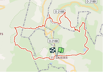

Length
12.9 km

Max alt
1879 m

Uphill gradient
496 m
Km-Effort
19.5 km

Min alt
1508 m

Downhill gradient
497 m
Boucle
Yes
Creation date :
2020-06-24 11:57:57.544
Updated on :
2020-06-24 11:58:46.849
--
Difficulty : Difficult

FREE GPS app for hiking
 SityTrail
IGN / Geographical institutes
SityTrail Plus
The world is yours!
About
Trail Running of 12.9 km to be discovered at Auvergne-Rhône-Alpes, Savoy, Hauteluce. This trail is proposed by jpb83.
Positioning
Country:
France
Region :
Auvergne-Rhône-Alpes
Department/Province :
Savoy
Municipality :
Hauteluce
Location:
Unknown
Start:(Dec)
Start:(UTM)
308329 ; 5070231 (32T) N.
Comments