Trail On foot La Capelle-Bleys - La Capelle Bleys - Photo
© OpenStreetMap contributors
Length
Length
9.8 km
Max alt
Max alt
674 m
Uphill gradient
Uphill gradient
228 m
Km-Effort
Km-Effort  
12.8 km
Min alt
Min alt
527 m
Downhill gradient
Downhill gradient
228 m
Boucle
Boucle
Yes
Creation date :
2020-06-24 07:03:52.295
Updated on :
2020-06-24 20:01:56.165

(1 Reviews)

On foot
On foot
2h45
Difficulty : Easy

Scan this QR Code to open this trail in the SityTrail application

FREE GPS app for hiking

Logo SityTrail SityTrail

IGN / Geographical institutes

Download SityTrail from the App Store Download SityTrail from Google Play

Logo SityTrail SityTrail World

The world is yours!

Download SityTrail from the App Store Download SityTrail from Google Play Download SityTrail on Huawei AppGallery

About

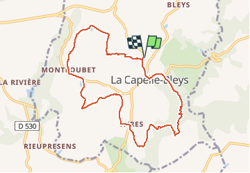
Trail On foot of 9.8 km to be discovered at Occitania, Aveyron, La Capelle-Bleys. This trail is proposed by BESSOU1294.

Elevation profile

Positioning

Country:
France
Region :
Occitania
Department/Province :
Aveyron
Municipality :
La Capelle-Bleys
Location:
Unknown
Start:(UTM)
434701 ; 4905356 (31T) N.

Comments

Please log in to post a review or rate the element


Trails nearby

Trail Cycle Rieupeyroux - Le Ségala, le Pays des 100 vallées - Rieupeyroux - Photo
Cycle
tracegps

Cycle

Difficult
Rieupeyroux, Occitania, Aveyron, France
71 km | 87 km-effort
4h 30min
Yes
Trail Walking Rieupeyroux - Rando Occitane  - Photo
Walking
brigittedelasource

Walking

Very easy
Rieupeyroux, Occitania, Aveyron, France
9.8 km | 13.2 km-effort
2h 54min
No
Trail Walking Rieupeyroux - Tour du Pradal - Photo
Walking
Benoît Marquès

Walking

Easy
Rieupeyroux, Occitania, Aveyron, France
3.9 km | 5.8 km-effort
1h 32min
Yes
Trail Mountain bike Rieupeyroux - Rieupeyroux - Prévinquière - Photo
Mountain bike
tracegps

Mountain bike

Difficult
Rieupeyroux, Occitania, Aveyron, France
23 km | 32 km-effort
2h 45min
Yes
Trail Walking Rieupeyroux - Rieupeyroux - Prévinquière - Photo
Walking
tracegps

Walking

Difficult
Rieupeyroux, Occitania, Aveyron, France
23 km | 32 km-effort
7h 0min
Yes
Trail Walking Le Bas Ségala - LA BASTIDE L'EVEQUE ET MARTINET DE LA RAMONDE - Photo
Walking
BESSOU1294

Walking

Easy
Le Bas Ségala, Occitania, Aveyron, France
5.7 km | 7.5 km-effort
1h 58min
Yes
Trail Trail Rieupeyroux - Balade vues sur les plateaux - Photo
Trail
Benoît Marquès

Trail

Medium
Rieupeyroux, Occitania, Aveyron, France
6.3 km | 9 km-effort
1h 0min
No
Trail Walking Le Bas Ségala - La Bastide L'Evêque 2 - Photo
Walking
BESSOU1294

Walking

Very easy
Le Bas Ségala, Occitania, Aveyron, France
10.7 km | 14.5 km-effort
2h 41min
Yes
Trail Walking Le Bas Ségala - La Bastide L'Evêque  - Photo
Walking
BESSOU1294

Walking

Easy
Le Bas Ségala, Occitania, Aveyron, France
9.9 km | 13.3 km-effort
2h 25min
Yes


Close
My subscriptions