


LES SAISIES 16KM

jpb83
User
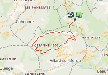

Length
15.9 km

Max alt
1935 m

Uphill gradient
828 m
Km-Effort
27 km

Min alt
1268 m

Downhill gradient
828 m
Boucle
Yes
Creation date :
2020-06-24 12:08:30.16
Updated on :
2020-06-24 12:09:54.006
5h29
Difficulty : Medium
2h00
Difficulty : Difficult
2h00
Difficulty : Difficult

FREE GPS app for hiking
 SityTrail
IGN / Geographical institutes
SityTrail Plus
The world is yours!
About
Trail Walking of 15.9 km to be discovered at Auvergne-Rhône-Alpes, Savoy, Hauteluce. This trail is proposed by jpb83.
Positioning
Country:
France
Region :
Auvergne-Rhône-Alpes
Department/Province :
Savoy
Municipality :
Hauteluce
Location:
Unknown
Start:(Dec)
Start:(UTM)
308609 ; 5070009 (32T) N.
Comments