


Tête des chaudières par le scialet de la combe de fer

gilder89
User
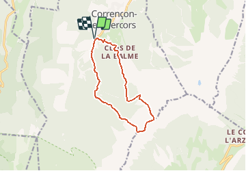

Length
11.1 km

Max alt
2014 m

Uphill gradient
892 m
Km-Effort
23 km

Min alt
1142 m

Downhill gradient
892 m
Boucle
Yes
Creation date :
2020-06-24 21:00:36.3
Updated on :
2020-08-17 07:16:09.996
4h32
Difficulty : Very difficult

FREE GPS app for hiking
 SityTrail
IGN / Geographical institutes
SityTrail Plus
The world is yours!
About
Trail Walking of 11.1 km to be discovered at Auvergne-Rhône-Alpes, Isère, Corrençon-en-Vercors. This trail is proposed by gilder89.
Positioning
Country:
France
Region :
Auvergne-Rhône-Alpes
Department/Province :
Isère
Municipality :
Corrençon-en-Vercors
Location:
Unknown
Start:(Dec)
Start:(UTM)
698328 ; 4988790 (31T) N.
Comments