


Lac du Sambuis (col du Glandon)

GOHIER
User
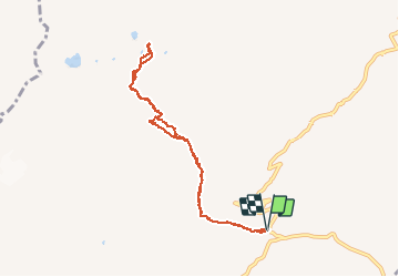

Length
8.7 km

Max alt
2469 m

Uphill gradient
583 m
Km-Effort
16.5 km

Min alt
1912 m

Downhill gradient
586 m
Boucle
Yes
Creation date :
2020-06-21 08:23:28.0
Updated on :
2020-06-27 08:27:23.904
6h55
Difficulty : Unknown

FREE GPS app for hiking
 SityTrail
IGN / Geographical institutes
SityTrail Plus
The world is yours!
About
Trail Walking of 8.7 km to be discovered at Auvergne-Rhône-Alpes, Savoy, Saint-Colomban-des-Villards. This trail is proposed by GOHIER.
Description
Avec Patou, Lauren et Geo
Positioning
Country:
France
Region :
Auvergne-Rhône-Alpes
Department/Province :
Savoy
Municipality :
Saint-Colomban-des-Villards
Location:
Unknown
Start:(Dec)
Start:(UTM)
278302 ; 5013455 (32T) N.
Comments