


freyr

christdevos
User
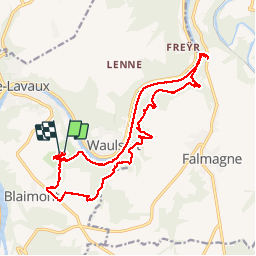

Length
18.4 km

Max alt
250 m

Uphill gradient
534 m
Km-Effort
26 km

Min alt
88 m

Downhill gradient
523 m
Boucle
Yes
Creation date :
2014-12-10 00:00:00.0
Updated on :
2014-12-10 00:00:00.0
10h04
Difficulty : Unknown

FREE GPS app for hiking
 SityTrail
IGN / Geographical institutes
SityTrail Plus
The world is yours!
About
Trail Walking of 18.4 km to be discovered at Wallonia, Namur, Hastière. This trail is proposed by christdevos.
Description
annif
Positioning
Country:
Belgium
Region :
Wallonia
Department/Province :
Namur
Municipality :
Hastière
Location:
Blaimont
Start:(Dec)
Start:(UTM)
631760 ; 5562694 (31U) N.
Comments