


bergholtzzell croix de mission boucle

stempfel52
User GUIDE
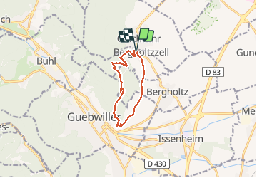

Length
9.2 km

Max alt
556 m

Uphill gradient
309 m
Km-Effort
13.3 km

Min alt
262 m

Downhill gradient
305 m
Boucle
Yes
Creation date :
2020-06-28 12:43:53.196
Updated on :
2020-06-28 18:25:03.798
2h43
Difficulty : Difficult

FREE GPS app for hiking
 SityTrail
IGN / Geographical institutes
SityTrail Plus
The world is yours!
About
Trail Walking of 9.2 km to be discovered at Grand Est, Haut-Rhin, Bergholtzzell. This trail is proposed by stempfel52.
Photos


Positioning
Country:
France
Region :
Grand Est
Department/Province :
Haut-Rhin
Municipality :
Bergholtzzell
Location:
Unknown
Start:(Dec)
Start:(UTM)
367966 ; 5310121 (32T) N.
Comments