


Rochehaut-Poupehan

Jaceu
User
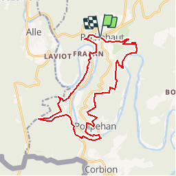

Length
16.9 km

Max alt
369 m

Uphill gradient
640 m
Km-Effort
25 km

Min alt
194 m

Downhill gradient
631 m
Boucle
Yes
Creation date :
2014-12-10 00:00:00.0
Updated on :
2014-12-10 00:00:00.0
5h23
Difficulty : Medium

FREE GPS app for hiking
 SityTrail
IGN / Geographical institutes
SityTrail Plus
The world is yours!
About
Trail Walking of 16.9 km to be discovered at Wallonia, Luxembourg, Bouillon. This trail is proposed by Jaceu.
Positioning
Country:
Belgium
Region :
Wallonia
Department/Province :
Luxembourg
Municipality :
Bouillon
Location:
Rochehaut
Start:(Dec)
Start:(UTM)
644252 ; 5522834 (31U) N.
Comments
Magnifique trace. On prend les Échelles dans le sens de la descente. Juste dommage d’être passé à côté du rocher de l’Ermitage dans la dernière montée quand on quitte la Semois. Sinon c’est top.
superbe, dans la nature tout le temps