


Balade le long de l'Eyre et à travers son delta

denissculier
User
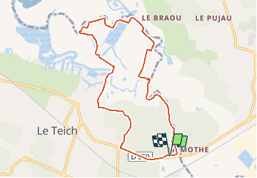

Length
9.4 km

Max alt
17 m

Uphill gradient
41 m
Km-Effort
9.9 km

Min alt
-2 m

Downhill gradient
44 m
Boucle
Yes
Creation date :
2020-07-01 16:23:33.25
Updated on :
2020-07-01 16:34:24.071
2h11
Difficulty : Medium

FREE GPS app for hiking
 SityTrail
IGN / Geographical institutes
SityTrail Plus
The world is yours!
About
Trail Nordic walking of 9.4 km to be discovered at New Aquitaine, Gironde, Le Teich. This trail is proposed by denissculier.
Positioning
Country:
France
Region :
New Aquitaine
Department/Province :
Gironde
Municipality :
Le Teich
Location:
Unknown
Start:(Dec)
Start:(UTM)
658747 ; 4943394 (30T) N.
Comments