


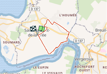
De la Pointe de la Parpagnole à Charras à Saint-Laurent-de-la-Prée

denissculier
User

Length
9.9 km

Max alt
19 m

Uphill gradient
48 m
Km-Effort
10.6 km

Min alt
-2 m

Downhill gradient
48 m
Boucle
Yes
Creation date :
2020-07-01 21:41:33.383
Updated on :
2020-07-01 22:00:00.856
2h21
Difficulty : Medium

FREE GPS app for hiking
 SityTrail
IGN / Geographical institutes
SityTrail Plus
The world is yours!
About
Trail Nordic walking of 9.9 km to be discovered at New Aquitaine, Charente-Maritime, Saint-Laurent-de-la-Prée. This trail is proposed by denissculier.
Positioning
Country:
France
Region :
New Aquitaine
Department/Province :
Charente-Maritime
Municipality :
Saint-Laurent-de-la-Prée
Location:
Unknown
Start:(Dec)
Start:(UTM)
651879 ; 5093639 (30T) N.
Comments