


RA2020 MIV Tour Tourbière Loigeroux

dfluzin
User
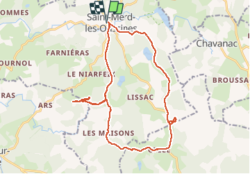

Length
19.2 km

Max alt
912 m

Uphill gradient
458 m
Km-Effort
25 km

Min alt
808 m

Downhill gradient
457 m
Boucle
Yes
Creation date :
2020-07-02 07:13:12.949
Updated on :
2020-07-02 13:57:30.624
5h32
Difficulty : Medium

FREE GPS app for hiking
 SityTrail
IGN / Geographical institutes
SityTrail Plus
The world is yours!
About
Trail Walking of 19.2 km to be discovered at New Aquitaine, Corrèze, Saint-Merd-les-Oussines. This trail is proposed by dfluzin.
Photos


Positioning
Country:
France
Region :
New Aquitaine
Department/Province :
Corrèze
Municipality :
Saint-Merd-les-Oussines
Location:
Unknown
Start:(Dec)
Start:(UTM)
425084 ; 5053653 (31T) N.
Comments