


Boucle 3h de Le Bourget (route des fonts) jusqu'au col de Bousson, et incursion jusqu'au premiers lacs Italiens

seghth
User
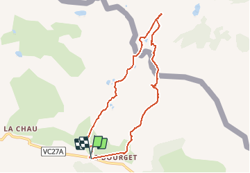

Length
8.1 km

Max alt
2190 m

Uphill gradient
369 m
Km-Effort
13 km

Min alt
1870 m

Downhill gradient
369 m
Boucle
Yes
Creation date :
2020-07-04 11:50:56.012
Updated on :
2020-07-05 12:26:08.008
2h40
Difficulty : Very easy

FREE GPS app for hiking
 SityTrail
IGN / Geographical institutes
SityTrail Plus
The world is yours!
About
Trail Walking of 8.1 km to be discovered at Provence-Alpes-Côte d'Azur, Hautes-Alpes, Cervières. This trail is proposed by seghth.
Description
3h yc picnic. Possibilité de réduire d'1/2 h en suivant la crête frontière à droite, sans incursion en Italie
Positioning
Country:
France
Region :
Provence-Alpes-Côte d'Azur
Department/Province :
Hautes-Alpes
Municipality :
Cervières
Location:
Unknown
Start:(Dec)
Start:(UTM)
323726 ; 4971485 (32T) N.
Comments