


val pelouse

Liebeaux
User
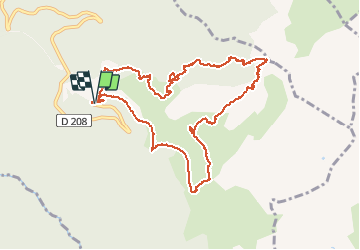

Length
11.4 km

Max alt
2024 m

Uphill gradient
733 m
Km-Effort
21 km

Min alt
1475 m

Downhill gradient
732 m
Boucle
Yes
Creation date :
2020-07-09 06:49:53.819
Updated on :
2020-07-09 13:48:13.805
6h56
Difficulty : Very easy

FREE GPS app for hiking
 SityTrail
IGN / Geographical institutes
SityTrail Plus
The world is yours!
About
Trail Walking of 11.4 km to be discovered at Auvergne-Rhône-Alpes, Savoy, Arvillard. This trail is proposed by Liebeaux.
Positioning
Country:
France
Region :
Auvergne-Rhône-Alpes
Department/Province :
Savoy
Municipality :
Arvillard
Location:
Unknown
Start:(Dec)
Start:(UTM)
278468 ; 5033347 (32T) N.
Comments