


lac du plan dessert

olivieraron
User
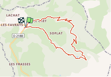

Length
9.9 km

Max alt
1731 m

Uphill gradient
426 m
Km-Effort
15.6 km

Min alt
1311 m

Downhill gradient
424 m
Boucle
Yes
Creation date :
2020-07-11 16:29:40.202
Updated on :
2020-07-11 16:38:17.628
3h13
Difficulty : Difficult

FREE GPS app for hiking
 SityTrail
IGN / Geographical institutes
SityTrail Plus
The world is yours!
About
Trail Walking of 9.9 km to be discovered at Auvergne-Rhône-Alpes, Savoy, Notre-Dame-de-Bellecombe. This trail is proposed by olivieraron.
Positioning
Country:
France
Region :
Auvergne-Rhône-Alpes
Department/Province :
Savoy
Municipality :
Notre-Dame-de-Bellecombe
Location:
Unknown
Start:(Dec)
Start:(UTM)
309601 ; 5075153 (32T) N.
Comments