Le Fournal au Col de Cabre
tbrunet
User
Length
15.2 km
Max alt
1642 m
Uphill gradient
664 m
Km-Effort
24 km
Min alt
1073 m
Downhill gradient
670 m
Boucle
Yes
Creation date :
2020-07-11 08:55:52.085
Updated on :
2020-07-11 17:50:40.217
7h39
Difficulty : Medium
FREE GPS app for hiking
About
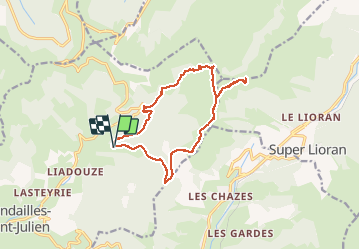
Trail Walking of 15.2 km to be discovered at Auvergne-Rhône-Alpes, Cantal, Mandailles-Saint-Julien. This trail is proposed by tbrunet.
Description
départ Le Fournal. Montée au Puy Griou. Traversée et montée au Téton de Venus. Retour par le col de Cabre et la source de la Jordanne.
Positioning
Country:
France
Region :
Auvergne-Rhône-Alpes
Department/Province :
Cantal
Municipality :
Mandailles-Saint-Julien
Location:
Unknown
Start:(Dec)
Start:(UTM)
475011 ; 4992301 (31T) N.
Comments
Trails nearby
Les crêtes du Cantal - Le Lioran
Walking
Difficult
(4)
Laveissière,
Auvergne-Rhône-Alpes,
Cantal,
France
28 km | 51 km-effort
7h 30min
Yes
L'Elancèze
Walking
Difficult
(1)
Mandailles-Saint-Julien,
Auvergne-Rhône-Alpes,
Cantal,
France
12.8 km | 24 km-effort
5h 0min
Yes
le Peyre Arse - Le Lioran
Walking
Difficult
(1)
Laveissière,
Auvergne-Rhône-Alpes,
Cantal,
France
11.2 km | 19.4 km-effort
4h 0min
No
Lioran 2023-08-18 Col de Rombière Col du Pertus A/R
Walking
Easy
(1)
Laveissière,
Auvergne-Rhône-Alpes,
Cantal,
France
12.5 km | 18.8 km-effort
4h 14min
Yes
Lioran 2023-08-11 Col du Pertus
Walking
Medium
(1)
Laveissière,
Auvergne-Rhône-Alpes,
Cantal,
France
17.3 km | 25 km-effort
2h 57min
Yes
Lioran 2023-08-09 Puy de Seycheuse
Walking
Very difficult
(1)
Laveissière,
Auvergne-Rhône-Alpes,
Cantal,
France
13.9 km | 23 km-effort
5h 20min
Yes
le falgoux
Walking
Easy
(1)
Le Falgoux,
Auvergne-Rhône-Alpes,
Cantal,
France
7.8 km | 10.4 km-effort
2h 22min
Yes
SityTrail - TABAZE Plomb du Cantal
Walking
Very difficult
Laveissière,
Auvergne-Rhône-Alpes,
Cantal,
France
35 km | 61 km-effort
13h 53min
Yes
Lioran 2023-08-17 Col de Gliziou Retour par Rombière
Walking
Easy
Laveissière,
Auvergne-Rhône-Alpes,
Cantal,
France
12.7 km | 21 km-effort
4h 41min
Yes