


gpx-trace.gpx

nandaf
User
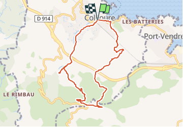

Length
9.2 km

Max alt
257 m

Uphill gradient
322 m
Km-Effort
13.5 km

Min alt
3 m

Downhill gradient
323 m
Boucle
Yes
Creation date :
2020-07-16 15:15:12.0
Updated on :
2024-02-20 17:12:33.414
3h03
Difficulty : Difficult

FREE GPS app for hiking
 SityTrail
IGN / Geographical institutes
SityTrail Plus
The world is yours!
About
Trail Walking of 9.2 km to be discovered at Occitania, Pyrénées-Orientales, Collioure. This trail is proposed by nandaf.
Description
Démarrer la Rando avenue du Maréchal de Gaulle à Collioure.
Positioning
Country:
France
Region :
Occitania
Department/Province :
Pyrénées-Orientales
Municipality :
Collioure
Location:
Unknown
Start:(Dec)
Start:(UTM)
506776 ; 4708018 (31T) N.
Comments