


73 - VALLOIRE

AndreLACOMBE
User
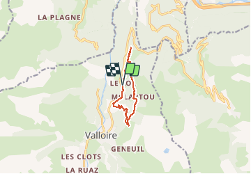

Length
8.4 km

Max alt
1764 m

Uphill gradient
298 m
Km-Effort
12.4 km

Min alt
1498 m

Downhill gradient
303 m
Boucle
Yes
Creation date :
2020-07-17 07:30:43.05
Updated on :
2020-07-17 12:08:32.488
4h36
Difficulty : Easy

FREE GPS app for hiking
 SityTrail
IGN / Geographical institutes
SityTrail Plus
The world is yours!
About
Trail Walking of 8.4 km to be discovered at Auvergne-Rhône-Alpes, Savoy, Valloire. This trail is proposed by AndreLACOMBE.
Description
Boucle des Trois Croix au départ du hameau du Col.
Positioning
Country:
France
Region :
Auvergne-Rhône-Alpes
Department/Province :
Savoy
Municipality :
Valloire
Location:
Unknown
Start:(Dec)
Start:(UTM)
298877 ; 5006426 (32T) N.
Comments