


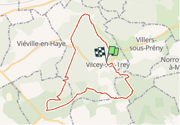
Vilcey sur Trey

Greg813
User

Length
17.2 km

Max alt
362 m

Uphill gradient
340 m
Km-Effort
22 km

Min alt
226 m

Downhill gradient
347 m
Boucle
Yes
Creation date :
2020-07-17 14:09:39.53
Updated on :
2020-07-21 16:27:29.146
4h50
Difficulty : Difficult

FREE GPS app for hiking
 SityTrail
IGN / Geographical institutes
SityTrail Plus
The world is yours!
About
Trail Walking of 17.2 km to be discovered at Grand Est, Meurthe-et-Moselle, Vilcey-sur-Trey. This trail is proposed by Greg813.
Description
Randonnée dans les forêts jouxtant Vilcey sur Trey.
Passage par les vestiges des positions allemandes de la première guerre mondiale.
Les chemins sont assez dégagés et bien entretenus.
Photos

Positioning
Country:
France
Region :
Grand Est
Department/Province :
Meurthe-et-Moselle
Municipality :
Vilcey-sur-Trey
Location:
Unknown
Start:(Dec)
Start:(UTM)
717681 ; 5424491 (31U) N.
Comments