


9 km | 25 km-effort


User GUIDE


FREE GPS app for hiking
 SityTrail
IGN / Geographical institutes
SityTrail World
The world is yours!
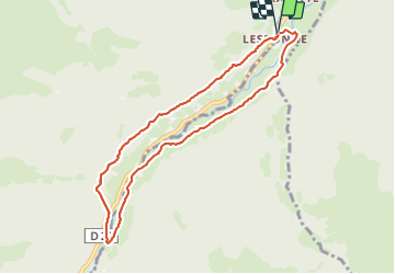
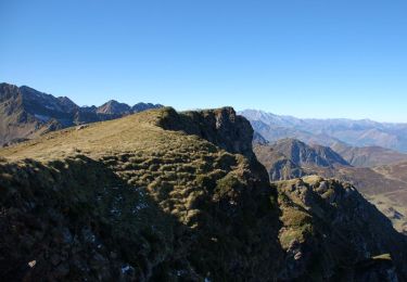
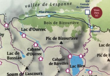
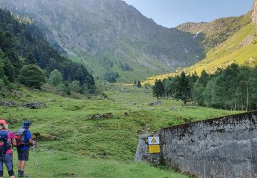
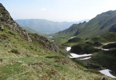
Trail Walking of 8.8 km to be discovered at Occitania, Hautespyrenees, Beaudéan. This trail is proposed by marmotte65.
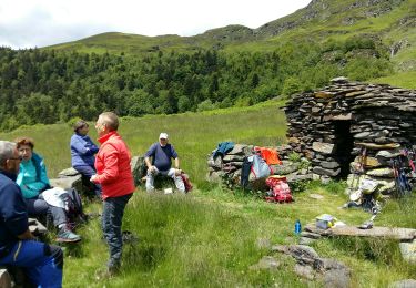
rando toujours aussi agréable a faire.
prévoir un départ de GER à 9h pour un pique nique au pied de la cascade vers 12h.
a faire en Mai ou debut Juin afin qu'il y ai plus d'eau et que la magie opere
 fait le 17 Juillet 2020") "
data-pinterest-text="Pin it"
data-tweet-text="share on twitter"
data-facebook-share-url="https://www.sitytrail.com/en/trails/2479379-beaudean--lesponne-entre-torrents-et-cascades-xg3x-fait-le-17-juillet-2020x2479379x/?photo=1#lg=1&slide=1"
data-twitter-share-url="https://www.sitytrail.com/en/trails/2479379-beaudean--lesponne-entre-torrents-et-cascades-xg3x-fait-le-17-juillet-2020x2479379x/?photo=1#lg=1&slide=1"
data-googleplus-share-url="https://www.sitytrail.com/en/trails/2479379-beaudean--lesponne-entre-torrents-et-cascades-xg3x-fait-le-17-juillet-2020x2479379x/?photo=1#lg=1&slide=1"
data-pinterest-share-url="https://www.sitytrail.com/en/trails/2479379-beaudean--lesponne-entre-torrents-et-cascades-xg3x-fait-le-17-juillet-2020x2479379x/?photo=1#lg=1&slide=1">
"
data-pinterest-text="Pin it"
data-tweet-text="share on twitter"
data-facebook-share-url="https://www.sitytrail.com/en/trails/2479379-beaudean--lesponne-entre-torrents-et-cascades-xg3x-fait-le-17-juillet-2020x2479379x/?photo=1#lg=1&slide=1"
data-twitter-share-url="https://www.sitytrail.com/en/trails/2479379-beaudean--lesponne-entre-torrents-et-cascades-xg3x-fait-le-17-juillet-2020x2479379x/?photo=1#lg=1&slide=1"
data-googleplus-share-url="https://www.sitytrail.com/en/trails/2479379-beaudean--lesponne-entre-torrents-et-cascades-xg3x-fait-le-17-juillet-2020x2479379x/?photo=1#lg=1&slide=1"
data-pinterest-share-url="https://www.sitytrail.com/en/trails/2479379-beaudean--lesponne-entre-torrents-et-cascades-xg3x-fait-le-17-juillet-2020x2479379x/?photo=1#lg=1&slide=1">
 fait le 17 Juillet 2020") "
data-pinterest-text="Pin it"
data-tweet-text="share on twitter"
data-facebook-share-url="https://www.sitytrail.com/en/trails/2479379-beaudean--lesponne-entre-torrents-et-cascades-xg3x-fait-le-17-juillet-2020x2479379x/?photo=2#lg=1&slide=2"
data-twitter-share-url="https://www.sitytrail.com/en/trails/2479379-beaudean--lesponne-entre-torrents-et-cascades-xg3x-fait-le-17-juillet-2020x2479379x/?photo=2#lg=1&slide=2"
data-googleplus-share-url="https://www.sitytrail.com/en/trails/2479379-beaudean--lesponne-entre-torrents-et-cascades-xg3x-fait-le-17-juillet-2020x2479379x/?photo=2#lg=1&slide=2"
data-pinterest-share-url="https://www.sitytrail.com/en/trails/2479379-beaudean--lesponne-entre-torrents-et-cascades-xg3x-fait-le-17-juillet-2020x2479379x/?photo=2#lg=1&slide=2">
"
data-pinterest-text="Pin it"
data-tweet-text="share on twitter"
data-facebook-share-url="https://www.sitytrail.com/en/trails/2479379-beaudean--lesponne-entre-torrents-et-cascades-xg3x-fait-le-17-juillet-2020x2479379x/?photo=2#lg=1&slide=2"
data-twitter-share-url="https://www.sitytrail.com/en/trails/2479379-beaudean--lesponne-entre-torrents-et-cascades-xg3x-fait-le-17-juillet-2020x2479379x/?photo=2#lg=1&slide=2"
data-googleplus-share-url="https://www.sitytrail.com/en/trails/2479379-beaudean--lesponne-entre-torrents-et-cascades-xg3x-fait-le-17-juillet-2020x2479379x/?photo=2#lg=1&slide=2"
data-pinterest-share-url="https://www.sitytrail.com/en/trails/2479379-beaudean--lesponne-entre-torrents-et-cascades-xg3x-fait-le-17-juillet-2020x2479379x/?photo=2#lg=1&slide=2">
 fait le 17 Juillet 2020") "
data-pinterest-text="Pin it"
data-tweet-text="share on twitter"
data-facebook-share-url="https://www.sitytrail.com/en/trails/2479379-beaudean--lesponne-entre-torrents-et-cascades-xg3x-fait-le-17-juillet-2020x2479379x/?photo=3#lg=1&slide=3"
data-twitter-share-url="https://www.sitytrail.com/en/trails/2479379-beaudean--lesponne-entre-torrents-et-cascades-xg3x-fait-le-17-juillet-2020x2479379x/?photo=3#lg=1&slide=3"
data-googleplus-share-url="https://www.sitytrail.com/en/trails/2479379-beaudean--lesponne-entre-torrents-et-cascades-xg3x-fait-le-17-juillet-2020x2479379x/?photo=3#lg=1&slide=3"
data-pinterest-share-url="https://www.sitytrail.com/en/trails/2479379-beaudean--lesponne-entre-torrents-et-cascades-xg3x-fait-le-17-juillet-2020x2479379x/?photo=3#lg=1&slide=3">
"
data-pinterest-text="Pin it"
data-tweet-text="share on twitter"
data-facebook-share-url="https://www.sitytrail.com/en/trails/2479379-beaudean--lesponne-entre-torrents-et-cascades-xg3x-fait-le-17-juillet-2020x2479379x/?photo=3#lg=1&slide=3"
data-twitter-share-url="https://www.sitytrail.com/en/trails/2479379-beaudean--lesponne-entre-torrents-et-cascades-xg3x-fait-le-17-juillet-2020x2479379x/?photo=3#lg=1&slide=3"
data-googleplus-share-url="https://www.sitytrail.com/en/trails/2479379-beaudean--lesponne-entre-torrents-et-cascades-xg3x-fait-le-17-juillet-2020x2479379x/?photo=3#lg=1&slide=3"
data-pinterest-share-url="https://www.sitytrail.com/en/trails/2479379-beaudean--lesponne-entre-torrents-et-cascades-xg3x-fait-le-17-juillet-2020x2479379x/?photo=3#lg=1&slide=3">
 fait le 17 Juillet 2020") "
data-pinterest-text="Pin it"
data-tweet-text="share on twitter"
data-facebook-share-url="https://www.sitytrail.com/en/trails/2479379-beaudean--lesponne-entre-torrents-et-cascades-xg3x-fait-le-17-juillet-2020x2479379x/?photo=4#lg=1&slide=4"
data-twitter-share-url="https://www.sitytrail.com/en/trails/2479379-beaudean--lesponne-entre-torrents-et-cascades-xg3x-fait-le-17-juillet-2020x2479379x/?photo=4#lg=1&slide=4"
data-googleplus-share-url="https://www.sitytrail.com/en/trails/2479379-beaudean--lesponne-entre-torrents-et-cascades-xg3x-fait-le-17-juillet-2020x2479379x/?photo=4#lg=1&slide=4"
data-pinterest-share-url="https://www.sitytrail.com/en/trails/2479379-beaudean--lesponne-entre-torrents-et-cascades-xg3x-fait-le-17-juillet-2020x2479379x/?photo=4#lg=1&slide=4">
"
data-pinterest-text="Pin it"
data-tweet-text="share on twitter"
data-facebook-share-url="https://www.sitytrail.com/en/trails/2479379-beaudean--lesponne-entre-torrents-et-cascades-xg3x-fait-le-17-juillet-2020x2479379x/?photo=4#lg=1&slide=4"
data-twitter-share-url="https://www.sitytrail.com/en/trails/2479379-beaudean--lesponne-entre-torrents-et-cascades-xg3x-fait-le-17-juillet-2020x2479379x/?photo=4#lg=1&slide=4"
data-googleplus-share-url="https://www.sitytrail.com/en/trails/2479379-beaudean--lesponne-entre-torrents-et-cascades-xg3x-fait-le-17-juillet-2020x2479379x/?photo=4#lg=1&slide=4"
data-pinterest-share-url="https://www.sitytrail.com/en/trails/2479379-beaudean--lesponne-entre-torrents-et-cascades-xg3x-fait-le-17-juillet-2020x2479379x/?photo=4#lg=1&slide=4">
 fait le 17 Juillet 2020") "
data-pinterest-text="Pin it"
data-tweet-text="share on twitter"
data-facebook-share-url="https://www.sitytrail.com/en/trails/2479379-beaudean--lesponne-entre-torrents-et-cascades-xg3x-fait-le-17-juillet-2020x2479379x/?photo=5#lg=1&slide=5"
data-twitter-share-url="https://www.sitytrail.com/en/trails/2479379-beaudean--lesponne-entre-torrents-et-cascades-xg3x-fait-le-17-juillet-2020x2479379x/?photo=5#lg=1&slide=5"
data-googleplus-share-url="https://www.sitytrail.com/en/trails/2479379-beaudean--lesponne-entre-torrents-et-cascades-xg3x-fait-le-17-juillet-2020x2479379x/?photo=5#lg=1&slide=5"
data-pinterest-share-url="https://www.sitytrail.com/en/trails/2479379-beaudean--lesponne-entre-torrents-et-cascades-xg3x-fait-le-17-juillet-2020x2479379x/?photo=5#lg=1&slide=5">
"
data-pinterest-text="Pin it"
data-tweet-text="share on twitter"
data-facebook-share-url="https://www.sitytrail.com/en/trails/2479379-beaudean--lesponne-entre-torrents-et-cascades-xg3x-fait-le-17-juillet-2020x2479379x/?photo=5#lg=1&slide=5"
data-twitter-share-url="https://www.sitytrail.com/en/trails/2479379-beaudean--lesponne-entre-torrents-et-cascades-xg3x-fait-le-17-juillet-2020x2479379x/?photo=5#lg=1&slide=5"
data-googleplus-share-url="https://www.sitytrail.com/en/trails/2479379-beaudean--lesponne-entre-torrents-et-cascades-xg3x-fait-le-17-juillet-2020x2479379x/?photo=5#lg=1&slide=5"
data-pinterest-share-url="https://www.sitytrail.com/en/trails/2479379-beaudean--lesponne-entre-torrents-et-cascades-xg3x-fait-le-17-juillet-2020x2479379x/?photo=5#lg=1&slide=5">
 fait le 17 Juillet 2020")

Walking
Walking
Walking
Walking

Road bike
Walking

Walking
Walking

Snowshoes