


col de chal par la montée des mille marches

XavierFaidix
User
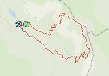

Length
6.9 km

Max alt
2135 m

Uphill gradient
591 m
Km-Effort
14.8 km

Min alt
1539 m

Downhill gradient
589 m
Boucle
Yes
Creation date :
2020-07-18 09:30:35.629
Updated on :
2020-07-18 14:21:09.65
2h20
Difficulty : Difficult

FREE GPS app for hiking
 SityTrail
IGN / Geographical institutes
SityTrail Plus
The world is yours!
About
Trail Walking of 6.9 km to be discovered at Auvergne-Rhône-Alpes, Savoy, Courchevel. This trail is proposed by XavierFaidix.
Positioning
Country:
France
Region :
Auvergne-Rhône-Alpes
Department/Province :
Savoy
Municipality :
Courchevel
Location:
Saint-Bon-Tarentaise
Start:(Dec)
Start:(UTM)
317535 ; 5030889 (32T) N.
Comments