


La voie Sarde

choubaka77
User
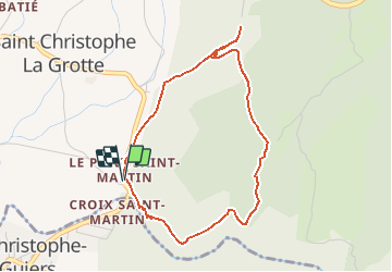

Length
4.1 km

Max alt
595 m

Uphill gradient
219 m
Km-Effort
7.1 km

Min alt
419 m

Downhill gradient
233 m
Boucle
Yes
Creation date :
2020-07-19 12:28:00.442
Updated on :
2020-07-19 12:33:28.424
1h25
Difficulty : Medium

FREE GPS app for hiking
 SityTrail
IGN / Geographical institutes
SityTrail Plus
The world is yours!
About
Trail Walking of 4.1 km to be discovered at Auvergne-Rhône-Alpes, Savoy, Saint-Christophe. This trail is proposed by choubaka77.
Positioning
Country:
France
Region :
Auvergne-Rhône-Alpes
Department/Province :
Savoy
Municipality :
Saint-Christophe
Location:
Unknown
Start:(Dec)
Start:(UTM)
717601 ; 5035964 (31T) N.
Comments