


Roche du Tétras - Bilstein

Claudele
User
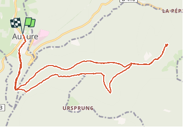

Length
13.3 km

Max alt
940 m

Uphill gradient
361 m
Km-Effort
18.1 km

Min alt
726 m

Downhill gradient
362 m
Boucle
Yes
Creation date :
2020-07-19 07:40:52.665
Updated on :
2020-07-19 19:31:13.93
5h01
Difficulty : Easy

FREE GPS app for hiking
 SityTrail
IGN / Geographical institutes
SityTrail Plus
The world is yours!
About
Trail Walking of 13.3 km to be discovered at Grand Est, Haut-Rhin, Aubure. This trail is proposed by Claudele.
Photos


Positioning
Country:
France
Region :
Grand Est
Department/Province :
Haut-Rhin
Municipality :
Aubure
Location:
Unknown
Start:(Dec)
Start:(UTM)
367825 ; 5339840 (32U) N.
Comments