


balisage GR10 21072020

LouisROGER
User GUIDE
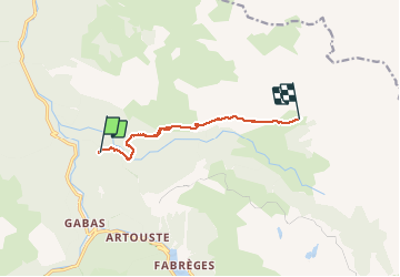

Length
7.7 km

Max alt
1702 m

Uphill gradient
719 m
Km-Effort
15.4 km

Min alt
1102 m

Downhill gradient
142 m
Boucle
No
Creation date :
2020-07-21 06:22:09.751
Updated on :
2020-07-21 15:18:33.662
4h45
Difficulty : Very easy

FREE GPS app for hiking
 SityTrail
IGN / Geographical institutes
SityTrail Plus
The world is yours!
About
Trail Walking of 7.7 km to be discovered at New Aquitaine, Pyrénées-Atlantiques, Laruns. This trail is proposed by LouisROGER.
Photos

Positioning
Country:
France
Region :
New Aquitaine
Department/Province :
Pyrénées-Atlantiques
Municipality :
Laruns
Location:
Unknown
Start:(Dec)
Start:(UTM)
710379 ; 4753552 (30T) N.
Comments