Trail Walking Carnoët - Carnoët  vers la vallée des Saints  - Photo

Carnoët vers la vallée des Saints

© OpenStreetMap contributors
Length
Length
11.2 km
Max alt
Max alt
234 m
Uphill gradient
Uphill gradient
229 m
Km-Effort
Km-Effort  
14.2 km
Min alt
Min alt
161 m
Downhill gradient
Downhill gradient
231 m
Boucle
Boucle
Yes
Creation date :
2020-07-22 12:17:59.656
Updated on :
2020-07-22 16:02:49.014

(0 Reviews)

Walking
Walking
3h43
Difficulty : Very easy

Scan this QR Code to open this trail in the SityTrail application

FREE GPS app for hiking

Logo SityTrail SityTrail

IGN / Geographical institutes

Download SityTrail from the App Store Download SityTrail from Google Play

Logo SityTrail SityTrail World

The world is yours!

Download SityTrail from the App Store Download SityTrail from Google Play Download SityTrail on Huawei AppGallery

About

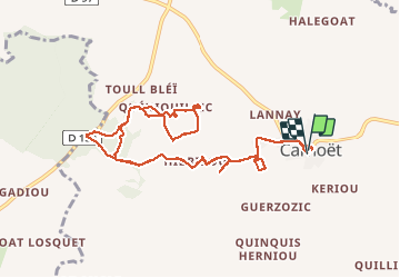
Trail Walking of 11.2 km to be discovered at Brittany, Côtes-d'Armor, Carnoët. This trail is proposed by MichelRando7656.

Description

Parcours avec souvent des chemins barrés pardes ficelles.
Une belle modification de parcours par les bois supprime 2km de goudron.
La vallée des Saint est intéressante.
Attention aux périodes de chasse.

Elevation profile

Photos

Positioning

Country:
France
Region :
Brittany
Department/Province :
Côtes-d'Armor
Municipality :
Carnoët
Location:
Unknown
Start:(UTM)
461439 ; 5357266 (30U) N.

Trails nearby

Trail Walking Plusquellec - Plusquellec - Circuit de Kerthomas - Photo
Walking
FabienneD

Walking

Very easy
Plusquellec, Brittany, Côtes-d'Armor, France
11.2 km | 13.6 km-effort
3h 0min
No


Close
My subscriptions