![](/images/other/stat-length.png)
![Trail Walking Puéchabon - puechabon - Photo](https://media.geolcdn.com/t/1900/400/ext.pjpeg?maxdim=2&url=https%3A%2F%2Fstatic1.geolcdn.com%2Fsiteimages%2Fupload%2Ffiles%2F1553511878bg_sport_marche.png)
puechabon
labarone
User
![Length](/images/other/stat-length.png)
Length
18.3 km
![Max alt](https://static1.geolcdn.com/siteimages/upload/files/1508320355ic_sort_altitude_max_24dp.png)
Max alt
466 m
![Uphill gradient](https://static1.geolcdn.com/siteimages/upload/files/1508320355ic_sort_den_pos_24dp.png)
Uphill gradient
522 m
![Km-Effort](/images/other/stat-length.png)
Km-Effort
25 km
![Min alt](https://static1.geolcdn.com/siteimages/upload/files/1508320355ic_sort_altitude_min_24dp.png)
Min alt
156 m
![Downhill gradient](https://static1.geolcdn.com/siteimages/upload/files/1508320355ic_sort_den_neg_24dp.png)
Downhill gradient
449 m
![Boucle](https://static1.geolcdn.com/siteimages/upload/files/16400158638029165_repeat_loop_refresh_sync_direction_icon.png)
Boucle
No
Creation date :
2020-07-23 06:49:48.113
Updated on :
2020-07-23 12:46:32.196
![Walking](https://static1.geolcdn.com/sitytour/trail-icons/101.png)
5h55
Difficulty : Medium
![Scan this QR Code to open this trail in the SityTrail application](https://capi.geolives.com/qq0zvz2zws4bq2lad0pu/sitytour/trails/2486924/qr.png?size=200)
FREE GPS app for hiking
About
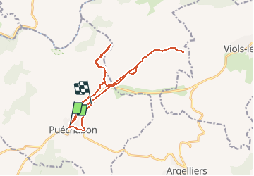
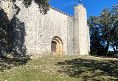
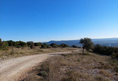
Trail Walking of 18.3 km to be discovered at Occitania, Hérault, Puéchabon. This trail is proposed by labarone.
Description
circuit à ne pas faire sauf si vous partez via le grp
tous les petits chemins vers les mas sont devenus privés.
de plus à éviter par cagnasses..a boire à boire...a quand la bière pression !!
Positioning
Country:
France
Region :
Occitania
Department/Province :
Hérault
Municipality :
Puéchabon
Location:
Unknown
Start:(Dec)
Start:(UTM)
549707 ; 4840474 (31T) N.
Comments
Trails nearby
![Trail Walking Aniane - Aniane ruisseau des Corbières - Photo](https://media.geolcdn.com/t/375/260/ext.jpg?maxdim=2&url=https%3A%2F%2Fservices.sitytrail.com%2FGeolivesWS%2FDownloadMedia.ashx%3FTrailID%3D371677%26Media%3D20141221154017.jpg)
![Walking Walking](https://static1.geolcdn.com/sitytour/trail-icons/101.png)
Aniane ruisseau des Corbières
Walking
Easy
(3)
Aniane,
Occitania,
Hérault,
France
![](/images/other/stat-length.png)
9.5 km | 12 km-effort
2h 34min
![](https://static1.geolcdn.com/siteimages/upload/files/16400158638029165_repeat_loop_refresh_sync_direction_icon.png)
Yes
![Trail Walking Saint-Guilhem-le-Désert - Herault - St-Guilhem-le-Desert le Roc de la Vigne depuis le barrage 12km 609m - Photo](https://media.geolcdn.com/t/375/260/ext.jpg?maxdim=2&url=https%3A%2F%2Fstatic1.geolcdn.com%2Fsiteimages%2Fupload%2Ffiles%2F1553511878bg_sport_marche.png)
![Walking Walking](https://static1.geolcdn.com/sitytour/trail-icons/101.png)
Herault - St-Guilhem-le-Desert le Roc de la Vigne depuis le barrage 12km 609m
Walking
Medium
(1)
Saint-Guilhem-le-Désert,
Occitania,
Hérault,
France
![](/images/other/stat-length.png)
12.1 km | 21 km-effort
4h 17min
![](https://static1.geolcdn.com/siteimages/upload/files/16400158638029165_repeat_loop_refresh_sync_direction_icon.png)
Yes
![Trail Walking Puéchabon - Causse Puechabon - Photo](https://media.geolcdn.com/t/375/260/ext.jpg?maxdim=2&url=https%3A%2F%2Fstatic1.geolcdn.com%2Fsiteimages%2Fupload%2Ffiles%2F1553511878bg_sport_marche.png)
![Walking Walking](https://static1.geolcdn.com/sitytour/trail-icons/101.png)
Causse Puechabon
Walking
Very easy
(1)
Puéchabon,
Occitania,
Hérault,
France
![](/images/other/stat-length.png)
12.8 km | 15.9 km-effort
Unknown
![](https://static1.geolcdn.com/siteimages/upload/files/16400158638029165_repeat_loop_refresh_sync_direction_icon.png)
Yes
![Trail Walking Saint-Guilhem-le-Désert - De baume en baumes à St Guilhem - Photo](https://media.geolcdn.com/t/375/260/ext.jpg?maxdim=2&url=https%3A%2F%2Fmedia.geolcdn.com%2Ff%2F050c206e-bec0-425f-8b81-0f24a249a5b8.jpg)
![Walking Walking](https://static1.geolcdn.com/sitytour/trail-icons/101.png)
De baume en baumes à St Guilhem
Walking
Medium
Saint-Guilhem-le-Désert,
Occitania,
Hérault,
France
![](/images/other/stat-length.png)
10 km | 15.8 km-effort
3h 28min
![](https://static1.geolcdn.com/siteimages/upload/files/16400158638029165_repeat_loop_refresh_sync_direction_icon.png)
No
![Trail Walking Puéchabon - Chapelle Saint-Sylvestre - Pioch de Ła Bastide - Photo](https://media.geolcdn.com/t/375/260/ext.jpg?maxdim=2&url=https%3A%2F%2Fmedia.geolcdn.com%2Ff%2F4441e2d5-932c-421a-a6dd-deaeea6979dd.jpg)
![Walking Walking](https://static1.geolcdn.com/sitytour/trail-icons/101.png)
Chapelle Saint-Sylvestre - Pioch de Ła Bastide
Walking
Difficult
Puéchabon,
Occitania,
Hérault,
France
![](/images/other/stat-length.png)
15.2 km | 19.3 km-effort
5h 27min
![](https://static1.geolcdn.com/siteimages/upload/files/16400158638029165_repeat_loop_refresh_sync_direction_icon.png)
Yes
![Trail Walking Puéchabon - Puechabon les crêtes de l’Herault - Photo](https://media.geolcdn.com/t/375/260/ext.jpg?maxdim=2&url=https%3A%2F%2Fmedia.geolcdn.com%2Ff%2Fc7bd78fa-f414-42bd-9938-fea417bb3fa7.jpg)
![Walking Walking](https://static1.geolcdn.com/sitytour/trail-icons/101.png)
Puechabon les crêtes de l’Herault
Walking
Very difficult
Puéchabon,
Occitania,
Hérault,
France
![](/images/other/stat-length.png)
19 km | 25 km-effort
6h 9min
![](https://static1.geolcdn.com/siteimages/upload/files/16400158638029165_repeat_loop_refresh_sync_direction_icon.png)
Yes
![Trail Walking Puéchabon - Le Plateau de Montcalmes par Puechabon - Photo](https://media.geolcdn.com/t/375/260/ext.jpg?maxdim=2&url=https%3A%2F%2Fmedia.geolcdn.com%2Ff%2F84ea9223-3f2e-4af8-9c1e-d39ae19bc16b.jpg)
![Walking Walking](https://static1.geolcdn.com/sitytour/trail-icons/101.png)
Le Plateau de Montcalmes par Puechabon
Walking
Difficult
Puéchabon,
Occitania,
Hérault,
France
![](/images/other/stat-length.png)
14.7 km | 18.3 km-effort
5h 41min
![](https://static1.geolcdn.com/siteimages/upload/files/16400158638029165_repeat_loop_refresh_sync_direction_icon.png)
Yes
![Trail Walking Argelliers - Arsel Argelliers Montarnaud - Photo](https://media.geolcdn.com/t/375/260/ext.jpg?maxdim=2&url=https%3A%2F%2Fmedia.geolcdn.com%2Ff%2Ff29931cb-207b-4689-a4f5-5240bd009557.jpg)
![Walking Walking](https://static1.geolcdn.com/sitytour/trail-icons/101.png)
Arsel Argelliers Montarnaud
Walking
Very easy
Argelliers,
Occitania,
Hérault,
France
![](/images/other/stat-length.png)
19.7 km | 24 km-effort
4h 20min
![](https://static1.geolcdn.com/siteimages/upload/files/16400158638029165_repeat_loop_refresh_sync_direction_icon.png)
Yes
![Trail Walking Aniane - grotte des reliques, montcalmes - Photo](https://media.geolcdn.com/t/375/260/ext.jpg?maxdim=2&url=https%3A%2F%2Fmedia.geolcdn.com%2Ff%2F04c124f2-06d4-4838-96bd-a85e3e562a11.jpg)
![Walking Walking](https://static1.geolcdn.com/sitytour/trail-icons/101.png)
grotte des reliques, montcalmes
Walking
Medium
Aniane,
Occitania,
Hérault,
France
![](/images/other/stat-length.png)
15.5 km | 19.7 km-effort
3h 45min
![](https://static1.geolcdn.com/siteimages/upload/files/16400158638029165_repeat_loop_refresh_sync_direction_icon.png)
Yes