Trail Walking Puéchabon - Chapelle Saint-Sylvestre - Pioch de Ła Bastide - Photo

Chapelle Saint-Sylvestre - Pioch de Ła Bastide

© OpenStreetMap contributors
Length
Length
15.2 km
Max alt
Max alt
330 m
Uphill gradient
Uphill gradient
302 m
Km-Effort
Km-Effort  
19.3 km
Min alt
Min alt
133 m
Downhill gradient
Downhill gradient
303 m
Boucle
Boucle
Yes
Creation date :
2023-03-16 08:29:49.0
Updated on :
2023-03-19 17:55:47.814

(0 Reviews)

Walking
Walking
5h27
Difficulty : Difficult

Scan this QR Code to open this trail in the SityTrail application

FREE GPS app for hiking

Logo SityTrail SityTrail

IGN / Geographical institutes

Download SityTrail from the App Store Download SityTrail from Google Play

Logo SityTrail SityTrail World

The world is yours!

Download SityTrail from the App Store Download SityTrail from Google Play Download SityTrail on Huawei AppGallery

About

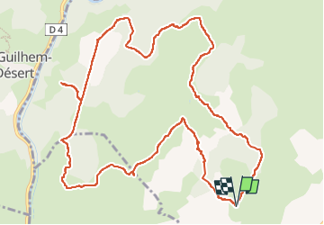
Trail Walking of 15.2 km to be discovered at Occitania, Hérault, Puéchabon. This trail is proposed by PiloudeBamako.

Description

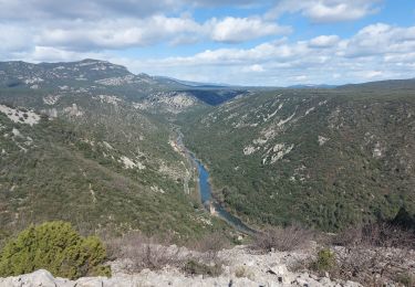
Randonnée offrant de belles vues sur les gorges de l'Hérault, notamment depuis un belvédère donnant sur Saint-Guilhem-le-Désert (partie de la trace en aller-retour sur 2 x 600 m).
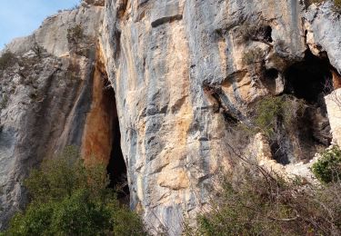
Attention: au départ, accès difficile à la Combe du Renard. Insister en suivant la trace, au besoin à l'aide de sécateurs sur quelques mètres... L'idée est de suivre le lit à sec du ruisseau en restant au fond de la combe entre les clapas.
Même problème au retour dans la descente vers l'arrivée. En suivant la trace fidèlement, on passe au travers du sous-bois, mais le sentier est quasiment effacé...
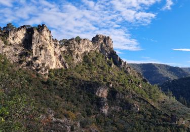
Le reste de la randonnée est facile une fois la montée vers le plateau réalisée  (300m de dénivelé).

Elevation profile

Photos

Positioning

Country:
France
Region :
Occitania
Department/Province :
Hérault
Municipality :
Puéchabon
Location:
Unknown
Start:(UTM)
547722 ; 4840342 (31T) N.

Trails nearby

Trail Walking Aniane - Aniane ruisseau des Corbières - Photo
Walking
kephas

Walking

Easy
(3)
Aniane, Occitania, Hérault, France
9.5 km | 12 km-effort
2h 34min
Yes
Trail Walking Saint-Jean-de-Fos - St Jean de fos Les Plos - Photo
Walking
mrclic34

Walking

Easy
(3)
Saint-Jean-de-Fos, Occitania, Hérault, France
11 km | 15.2 km-effort
3h 5min
Yes
Trail Walking Saint-Guilhem-le-Désert - Herault - St-Guilhem-le-Desert le Roc de la Vigne depuis le barrage 12km 609m - Photo
Walking
RandoVal

Walking

Medium
(1)
Saint-Guilhem-le-Désert, Occitania, Hérault, France
12.1 km | 21 km-effort
4h 17min
Yes
Trail Walking Saint-Jean-de-Fos - St Jean de Fos et le Max Nègre - Photo
Walking
GUIDE
randotines

Walking

Medium
Saint-Jean-de-Fos, Occitania, Hérault, France
19.1 km | 27 km-effort
5h 42min
Yes
Trail Walking Puéchabon - Causse Puechabon - Photo
Walking
dpop34

Walking

Very easy
(1)
Puéchabon, Occitania, Hérault, France
12.8 km | 15.9 km-effort
Unknown
Yes
Trail Walking Saint-Guilhem-le-Désert - St Guilhem Le Désert - Mas Aubert - Photo
Walking
tracegps

Walking

Difficult
(1)
Saint-Guilhem-le-Désert, Occitania, Hérault, France
19.7 km | 30 km-effort
6h 30min
Yes
Trail Walking Saint-Guilhem-le-Désert - de Saint guilhem le désert au plot - Photo
Walking
labarone

Walking

Medium
Saint-Guilhem-le-Désert, Occitania, Hérault, France
16.8 km | 26 km-effort
6h 5min
Yes
Trail Walking Saint-Guilhem-le-Désert - De baume en baumes à St Guilhem  - Photo
Walking
oduriez

Walking

Medium
Saint-Guilhem-le-Désert, Occitania, Hérault, France
10 km | 15.8 km-effort
3h 28min
No
Trail Walking Saint-Guilhem-le-Désert - Saint Guilhem le Désert  - Photo
Walking
GUIDE
nadinebondoux

Walking

Difficult
(1)
Saint-Guilhem-le-Désert, Occitania, Hérault, France
13.9 km | 22 km-effort
4h 32min
Yes


Close
My subscriptions