


Refuge Col du Palet - Refuge de la Martin

i20
User
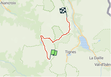

Length
16.4 km

Max alt
2700 m

Uphill gradient
778 m
Km-Effort
28 km

Min alt
2077 m

Downhill gradient
1209 m
Boucle
No
Creation date :
2020-07-27 05:42:30.907
Updated on :
2020-07-27 15:42:41.888
7h54
Difficulty : Very easy

FREE GPS app for hiking
 SityTrail
IGN / Geographical institutes
SityTrail Plus
The world is yours!
About
Trail Walking of 16.4 km to be discovered at Auvergne-Rhône-Alpes, Savoy, Peisey-Nancroix. This trail is proposed by i20.
Positioning
Country:
France
Region :
Auvergne-Rhône-Alpes
Department/Province :
Savoy
Municipality :
Peisey-Nancroix
Location:
Unknown
Start:(Dec)
Start:(UTM)
332791 ; 5036065 (32T) N.
Comments