


Refuge de la Martin - Les Arcs 2000

i20
User
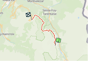

Length
15.9 km

Max alt
2422 m

Uphill gradient
1128 m
Km-Effort
31 km

Min alt
1581 m

Downhill gradient
1168 m
Boucle
No
Creation date :
2020-07-28 05:01:32.083
Updated on :
2020-07-28 12:14:10.219
5h58
Difficulty : Very easy

FREE GPS app for hiking
 SityTrail
IGN / Geographical institutes
SityTrail Plus
The world is yours!
About
Trail Walking of 15.9 km to be discovered at Auvergne-Rhône-Alpes, Savoy, Villaroger. This trail is proposed by i20.
Positioning
Country:
France
Region :
Auvergne-Rhône-Alpes
Department/Province :
Savoy
Municipality :
Villaroger
Location:
Unknown
Start:(Dec)
Start:(UTM)
336005 ; 5043280 (32T) N.
Comments