


VAL PEROUSE

d.rochas
User
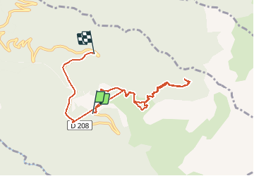

Length
8.8 km

Max alt
1846 m

Uphill gradient
550 m
Km-Effort
17.2 km

Min alt
1379 m

Downhill gradient
864 m
Boucle
No
Creation date :
2020-07-28 08:19:33.201
Updated on :
2020-07-28 12:53:54.534
3h34
Difficulty : Easy

FREE GPS app for hiking
 SityTrail
IGN / Geographical institutes
SityTrail Plus
The world is yours!
About
Trail Walking of 8.8 km to be discovered at Auvergne-Rhône-Alpes, Savoy, Arvillard. This trail is proposed by d.rochas.
Description
Miirtille
Positioning
Country:
France
Region :
Auvergne-Rhône-Alpes
Department/Province :
Savoy
Municipality :
Arvillard
Location:
Unknown
Start:(Dec)
Start:(UTM)
278429 ; 5033339 (32T) N.
Comments